Villeneuve geodata
Villeneuve (Provence-Alpes-Côte d'Azur) is a populated place; located in France in Europe/Paris (GMT+2) time zone. With population of 3,444 people, there are 2819 cities with bigger population in this country. Compared to other cities in France, 80.1% of cities are located further ↑North; 92.1% of cities are located further ←West and 99.8% of cities have lower elevation than Villeneuve. Note1
Administrative division(s):
- Level 1: Provence-Alpes-Côte d'Azur
- Level 2: Hautes-Alpes
- Level 3: Arrondissement de Briançon
- Level 4: La Salle-les-Alpes


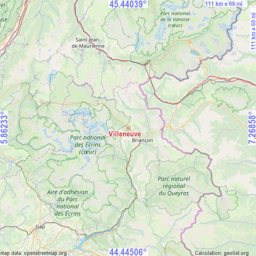
Villeneuve GPS coordinates[2]
44° 56' 41.568" North, 6° 33' 55.62" East
| Map corner | latitude | longitude |
|---|---|---|
| Upper-left | 45.44039°, | 5.86233° |
| Center: | 44.94488°, | 6.56545° |
| Lower-right: | 44.44506°, | 7.26858° |
| Map W x H: | 110.7×110.7 km | = 68.8×68.8mi |
| max Lat: | 51.07786° ⇑80.1% North |
| Villeneuve: | 44.94488° |
| min Lat: | ⇓19.9% South 41.3874° |
| min Long | Villeneuve | max Long |
| -5.08615° | 6.56545° | 9.52242° |
| W 92.1%⇐ | ⇒7.9% E |
Elevation
Elevation of Villeneuve is 1395 m = 4577 ft, and this is 1201.3 m = 3941 ft above average elevation for this country.
| Max E: |
2333 m = 7654 ft | 0.2% |
| Villeneuve | 1395 m 4577 ft | |
| Avg. | 193.7 m = 635 ft | |
Min E: |
-1 m = -3 ft | 99.8% |
See also: France elevation on elevation.city.
Geographical zone
Villeneuve is located in North temperate zone (between Tropic of Cancer and the Arctic Circle). Distance of this Northern Tropic circle is 2391.5 km =1486 mi to South.| Distance of | km | miles | from Villeneuve |
|---|---|---|---|
| North Pole | 5009.7 | 3112.9 | to North |
| Arctic Circle | 2403.8 | 1493.7 | to North |
| Tropic Cancer | 2391.5 | 1486 | to South |
| Equator | 4997.4 | 3105.2 | to South |


Nearby cities:
15 places around Villeneuve: (largest is in red/bold)
• Albanne
31.2 km =19.4 mi,  338°
338°
• Briançon
7.8 km =4.8 mi,  129°
129°
• Fourneaux
28 km =17.4 mi,  13°
13°
• La Roche-de-Rame
21.7 km =13.5 mi,  177°
177°
• Le Monêtier-les-Bains
5.6 km =3.5 mi,  307°
307°
• Modane
29.5 km =18.3 mi,  15°
15°
• Montgenèvre
12.4 km =7.7 mi,  96°
96°
• Saint-Chaffrey
4 km =2.5 mi,  122°
122°
• Saint-Crépin
26.7 km =16.6 mi,  172°
172°
• Saint-Martin-de-Queyrières
13.6 km =8.5 mi, 175°
• Val-des-Prés
8.9 km =5.5 mi,  86°
86°
• Valloire
26.7 km =16.6 mi, 336°
• Vallouise
12.5 km =7.8 mi,  208°
208°
• Valmeinier
27.6 km =17.1 mi,  346°
346°
• Villar-Saint-Pancrace
9.3 km =5.8 mi,  148°
148°
Sources, notices
• [Note1] Compared only with cities in France existing in our database
• [Src1] Map data: © OpenStreetMap contributors (CC-BY-SA)
• [Src2] Other city data from geonames.org with taken over terms of usage.
• [Src3] Geographical zone / Annual Mean Temperature by Robert A. Rohde @ Wikipedia
