Briançon geodata
Briançon (Provence-Alpes-Côte d'Azur) is a seat of a third-order administrative division; located in France in Europe/Paris (GMT+2) time zone. With population of 11,577 people, there are 830 cities with bigger population in this country. Compared to other cities in France, 80.5% of cities are located further ↑North; 92.6% of cities are located further ←West and 99.8% of cities have lower elevation than Briançon. Note1
Administrative division(s):
- Level 1: Provence-Alpes-Côte d'Azur
- Level 2: Hautes-Alpes
- Level 3: Arrondissement de Briançon
- Level 4: Briançon


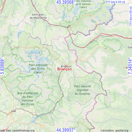
Briançon GPS coordinates[2]
44° 53' 59.208" North, 6° 38' 31.236" East
| Map corner | latitude | longitude |
|---|---|---|
| Upper-left | 45.39568°, | 5.93889° |
| Center: | 44.89978°, | 6.64201° |
| Lower-right: | 44.39957°, | 7.34514° |
| Map W x H: | 110.8×110.8 km | = 68.8×68.8mi |
| max Lat: | 51.07786° ⇑80.5% North |
| Briançon: | 44.89978° |
| min Lat: | ⇓19.5% South 41.3874° |
| min Long | Briançon | max Long |
| -5.08615° | 6.64201° | 9.52242° |
| W 92.6%⇐ | ⇒7.4% E |
Elevation
Elevation of Briançon is 1301 m = 4268 ft, and this is 1107.3 m = 3633 ft above average elevation for this country.
| Max E: |
2333 m = 7654 ft | 0.2% |
| Briançon | 1301 m 4268 ft | |
| Avg. | 193.7 m = 635 ft | |
Min E: |
-1 m = -3 ft | 99.8% |
See also: France elevation on elevation.city.
Geographical zone
Briançon is located in North temperate zone (between Tropic of Cancer and the Arctic Circle). Distance of this Northern Tropic circle is 2386.5 km =1482.9 mi to South.| Distance of | km | miles | from Briançon |
|---|---|---|---|
| North Pole | 5014.7 | 3116 | to North |
| Arctic Circle | 2408.8 | 1496.8 | to North |
| Tropic Cancer | 2386.5 | 1482.9 | to South |
| Equator | 4992.4 | 3102.1 | to South |


Nearby cities:
15 places around Briançon: (largest is in red/bold)
• Châteauroux-les-Alpes
33.1 km =20.6 mi,  196°
196°
• Fourneaux
32.3 km =20.1 mi,  1°
1°
• Guillestre
26.7 km =16.6 mi,  178°
178°
• La Roche-de-Rame
17.3 km =10.7 mi, 196°
• Le Monêtier-les-Bains
13.5 km =8.4 mi,  309°
309°
• Modane
33.5 km =20.8 mi, 3°
• Montgenèvre
7.2 km =4.5 mi,  60°
60°
• Risoul
28 km =17.4 mi, 180°
• Saint-Chaffrey
3.9 km =2.4 mi,  316°
316°
• Saint-Crépin
21.7 km =13.5 mi,  187°
187°
• Saint-Martin-de-Queyrières
9.9 km =6.2 mi,  210°
210°
• Val-des-Prés
6.2 km =3.9 mi,  27°
27°
• Vallouise
13.5 km =8.4 mi,  243°
243°
• Villar-Saint-Pancrace
3.2 km =2 mi, 202°
• Villeneuve
7.8 km =4.8 mi, 309°
Sources, notices
• [Note1] Compared only with cities in France existing in our database
• [Src1] Map data: © OpenStreetMap contributors (CC-BY-SA)
• [Src2] Other city data from geonames.org with taken over terms of usage.
• [Src3] Geographical zone / Annual Mean Temperature by Robert A. Rohde @ Wikipedia
