Châteauroux-les-Alpes geodata
Châteauroux-les-Alpes (Provence-Alpes-Côte d'Azur) is a populated place; located in France in Europe/Paris (GMT+2) time zone. With population of 993 people, there are 8879 cities with bigger population in this country. Compared to other cities in France, 82.7% of cities are located further ↑North; 91.8% of cities are located further ←West and 98.9% of cities have lower elevation than Châteauroux-les-Alpes. Note1
Administrative division(s):
- Level 1: Provence-Alpes-Côte d'Azur
- Level 2: Hautes-Alpes
- Level 3: Arrondissement de Gap
- Level 4: Châteauroux-les-Alpes
Current local time in Châteauroux-les-Alpes:
05:52 AM, WednesdayDifference from your time zone: hours


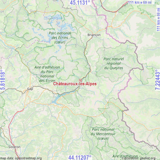
Châteauroux-les-Alpes GPS coordinates[2]
44° 36' 53.064" North, 6° 31' 16.68" East
| Map corner | latitude | longitude |
|---|---|---|
| Upper-left | 45.1131°, | 5.81818° |
| Center: | 44.61474°, | 6.5213° |
| Lower-right: | 44.11207°, | 7.22443° |
| Map W x H: | 111.3×111.3 km | = 69.2×69.2mi |
| max Lat: | 51.07786° ⇑82.7% North |
| Châteauroux-les-Alpes: | 44.61474° |
| min Lat: | ⇓17.3% South 41.3874° |
| min Long | Châteauroux-le | max Long |
| -5.08615° | 6.5213° | 9.52242° |
| W 91.8%⇐ | ⇒8.2% E |
Elevation
Elevation of Châteauroux-les-Alpes is 937 m = 3074 ft, and this is 743.3 m = 2439 ft above average elevation for this country.
| Max E: |
2333 m = 7654 ft | 1.1% |
| Châteauroux-les-Alpes | 937 m 3074 ft | |
| Avg. | 193.7 m = 635 ft | |
Min E: |
-1 m = -3 ft | 98.9% |
See also: France elevation on elevation.city.
Geographical zone
Châteauroux-les-Alpes is located in North temperate zone (between Tropic of Cancer and the Arctic Circle). Distance of this Northern Tropic circle is 2354.8 km =1463.2 mi to South.| Distance of | km | miles | from Châteauroux-les-Alpes |
|---|---|---|---|
| North Pole | 5046.4 | 3135.7 | to North |
| Arctic Circle | 2440.5 | 1516.5 | to North |
| Tropic Cancer | 2354.8 | 1463.2 | to South |
| Equator | 4960.7 | 3082.4 | to South |


Nearby cities:
15 places around Châteauroux-les-Alpes: (largest is in red/bold)
• Ancelle
25 km =15.5 mi,  272°
272°
• Barcelonnette
27.4 km =17 mi,  157°
157°
• Chorges
20.7 km =12.9 mi,  249°
249°
• Embrun
6 km =3.7 mi,  200°
200°
• Guillestre
11.3 km =7 mi,  63°
63°
• La Bâtie-Neuve
26.3 km =16.3 mi,  258°
258°
• La Roche-de-Rame
15.8 km =9.8 mi,  17°
17°
• Orcières
17.4 km =10.8 mi,  296°
296°
• Risoul
10 km =6.2 mi,  68°
68°
• Saint-Crépin
12.2 km =7.6 mi,  33°
33°
• Saint-Jean
24.9 km =15.5 mi,  284°
284°
• Saint-Martin-de-Queyrières
23.6 km =14.7 mi,  11°
11°
• Savines-le-Lac
13.5 km =8.4 mi,  223°
223°
• Vallouise
25.9 km =16.1 mi,  354°
354°
• Vars
13.6 km =8.5 mi,  98°
98°
In other languages:
- In France: Châteauroux-les-Alpes, Châteauroux
- In Russian: Шатору-лез-Альп
- In Chinese: 沙托鲁莱阿尔佩
Sources, notices
• [Note1] Compared only with cities in France existing in our database
• [Src1] Map data: © OpenStreetMap contributors (CC-BY-SA)
• [Src2] Other city data from geonames.org with taken over terms of usage.
• [Src3] Geographical zone / Annual Mean Temperature by Robert A. Rohde @ Wikipedia
