Quincy geodata
Quincy (Centre) is a populated place; located in France in Europe/Paris (GMT+2) time zone. With population of 789 people, there are 10726 cities with bigger population in this country. Compared to other cities in France, 53.9% of cities are located further ↑North; 55.1% of cities are located further →East and 52.6% of cities have higher elevation than Quincy. Note1
Administrative division(s):
- Level 1: Centre
- Level 2: Cher
- Level 3: Arrondissement de Vierzon
- Level 4: Quincy


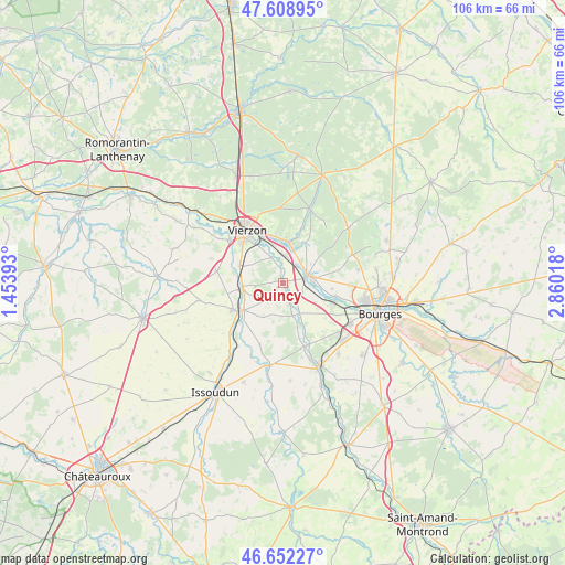
Quincy GPS coordinates[2]
47° 7' 57.936" North, 2° 9' 25.38" East
| Map corner | latitude | longitude |
|---|---|---|
| Upper-left | 47.60895°, | 1.45393° |
| Center: | 47.13276°, | 2.15705° |
| Lower-right: | 46.65227°, | 2.86018° |
| Map W x H: | 106.4×106.4 km | = 66.1×66.1mi |
| max Lat: | 51.07786° ⇑53.9% North |
| Quincy: | 47.13276° |
| min Lat: | ⇓46.1% South 41.3874° |
| min Long | Quincy | max Long |
| -5.08615° | 2.15705° | 9.52242° |
| W 44.9%⇐ | ⇒55.1% E |
Elevation
Elevation of Quincy is 123 m = 404 ft, and this is 70.7 m = 232 ft below average elevation for this country.
| Max E: |
2333 m = 7654 ft | 52.6% |
| Avg. | 193.7 m = 635 ft | |
| Quincy | 123 m = 404 ft | |
Min E: |
-1 m = -3 ft | 47.4% |
See also: France elevation on elevation.city.
Geographical zone
Quincy is located in North temperate zone (between Tropic of Cancer and the Arctic Circle). Distance of this North polar circle is 2160.5 km =1342.5 mi to North.| Distance of | km | miles | from Quincy |
|---|---|---|---|
| North Pole | 4766.4 | 2961.7 | to North |
| Arctic Circle | 2160.5 | 1342.5 | to North |
| Tropic Cancer | 2634.8 | 1637.2 | to South |
| Equator | 5240.7 | 3256.4 | to South |


Nearby cities:
15 places around Quincy: (largest is in red/bold)
• Allouis
6.4 km =4 mi,  55°
55°
• Berry-Bouy
10.3 km =6.4 mi,  104°
104°
• Foëcy
4.8 km =3 mi,  4°
4°
• La Chapelle-Saint-Ursin
14.9 km =9.3 mi,  121°
121°
• Lury-sur-Arnon
7.6 km =4.7 mi,  265°
265°
• Marmagne
10.2 km =6.3 mi,  110°
110°
• Massay
12.6 km =7.8 mi,  280°
280°
• Mehun-sur-Yèvre
4.1 km =2.5 mi,  82°
82°
• Morthomiers
13.8 km =8.6 mi,  139°
139°
• Méreau
8.7 km =5.4 mi,  292°
292°
• Reuilly
10.1 km =6.3 mi,  238°
238°
• Saint-Hilaire-de-Court
13.2 km =8.2 mi,  307°
307°
• Saint-Éloy-de-Gy
14.3 km =8.9 mi, 79°
• Vierzon
12 km =7.5 mi,  325°
325°
• Vignoux-sur-Barangeon
7.6 km =4.7 mi,  8°
8°
Sources, notices
• [Note1] Compared only with cities in France existing in our database
• [Src1] Map data: © OpenStreetMap contributors (CC-BY-SA)
• [Src2] Other city data from geonames.org with taken over terms of usage.
• [Src3] Geographical zone / Annual Mean Temperature by Robert A. Rohde @ Wikipedia
