Allouis geodata
Allouis (Centre) is a populated place; located in France in Europe/Paris (GMT+2) time zone. With population of 776 people, there are 10868 cities with bigger population in this country. Compared to other cities in France, 53.5% of cities are located further ↑North; 54% of cities are located further →East and 50.5% of cities have higher elevation than Allouis. Note1
Administrative division(s):
- Level 1: Centre
- Level 2: Cher
- Level 3: Arrondissement de Vierzon
- Level 4: Allouis


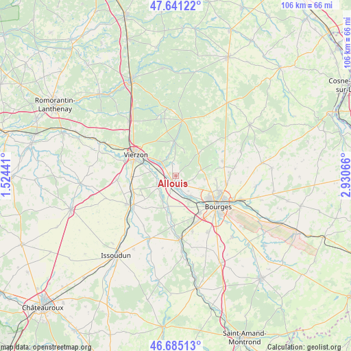
Allouis GPS coordinates[2]
47° 9' 55.188" North, 2° 13' 39.108" East
| Map corner | latitude | longitude |
|---|---|---|
| Upper-left | 47.64122°, | 1.52441° |
| Center: | 47.16533°, | 2.22753° |
| Lower-right: | 46.68513°, | 2.93066° |
| Map W x H: | 106.3×106.3 km | = 66.1×66.1mi |
| max Lat: | 51.07786° ⇑53.5% North |
| Allouis: | 47.16533° |
| min Lat: | ⇓46.5% South 41.3874° |
| min Long | Allouis | max Long |
| -5.08615° | 2.22753° | 9.52242° |
| W 46%⇐ | ⇒54% E |
Elevation
Elevation of Allouis is 130 m = 427 ft, and this is 63.7 m = 209 ft below average elevation for this country.
| Max E: |
2333 m = 7654 ft | 50.5% |
| Avg. | 193.7 m = 635 ft | |
| Allouis | 130 m = 427 ft | |
Min E: |
-1 m = -3 ft | 49.5% |
See also: France elevation on elevation.city.
Geographical zone
Allouis is located in North temperate zone (between Tropic of Cancer and the Arctic Circle). Distance of this North polar circle is 2156.9 km =1340.2 mi to North.| Distance of | km | miles | from Allouis |
|---|---|---|---|
| North Pole | 4762.8 | 2959.5 | to North |
| Arctic Circle | 2156.9 | 1340.2 | to North |
| Tropic Cancer | 2638.4 | 1639.4 | to South |
| Equator | 5244.3 | 3258.7 | to South |


Nearby cities:
15 places around Allouis: (largest is in red/bold)
• Allogny
9.7 km =6 mi,  46°
46°
• Berry-Bouy
7.7 km =4.8 mi,  143°
143°
• Foëcy
5.1 km =3.2 mi,  283°
283°
• La Chapelle-Saint-Ursin
13.6 km =8.5 mi,  147°
147°
• Lury-sur-Arnon
13.6 km =8.5 mi,  251°
251°
• Marmagne
8.4 km =5.2 mi, 149°
• Mehun-sur-Yèvre
3.3 km =2.1 mi,  202°
202°
• Méreau
13.4 km =8.3 mi,  268°
268°
• Quincy
6.4 km =4 mi,  235°
235°
• Saint-Doulchard
11.6 km =7.2 mi,  126°
126°
• Saint-Éloy-de-Gy
8.8 km =5.5 mi,  97°
97°
• Vasselay
12.3 km =7.6 mi,  94°
94°
• Vierzon
13.6 km =8.5 mi,  297°
297°
• Vignoux-sur-Barangeon
5.7 km =3.5 mi,  313°
313°
• Vouzeron
10.5 km =6.5 mi,  357°
357°
Sources, notices
• [Note1] Compared only with cities in France existing in our database
• [Src1] Map data: © OpenStreetMap contributors (CC-BY-SA)
• [Src2] Other city data from geonames.org with taken over terms of usage.
• [Src3] Geographical zone / Annual Mean Temperature by Robert A. Rohde @ Wikipedia
