Vouzeron geodata
Vouzeron (Centre) is a populated place; located in France in Europe/Paris (GMT+2) time zone. With population of 525 people, there are 14719 cities with bigger population in this country. Compared to other cities in France, 52.2% of cities are located further ↑North; 54% of cities are located further →East and 50.5% of cities have higher elevation than Vouzeron. Note1
Administrative division(s):
- Level 1: Centre
- Level 2: Cher
- Level 3: Arrondissement de Vierzon
- Level 4: Vouzeron


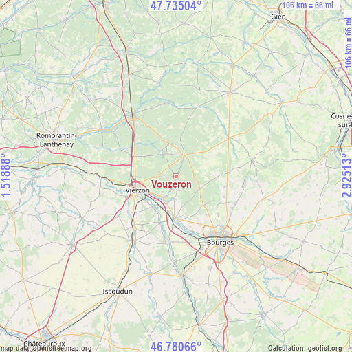
Vouzeron GPS coordinates[2]
47° 15' 36" North, 2° 13' 19.236" East
| Map corner | latitude | longitude |
|---|---|---|
| Upper-left | 47.73504°, | 1.51888° |
| Center: | 47.26°, | 2.22201° |
| Lower-right: | 46.78066°, | 2.92513° |
| Map W x H: | 106.1×106.1 km | = 65.9×65.9mi |
| max Lat: | 51.07786° ⇑52.2% North |
| Vouzeron: | 47.26° |
| min Lat: | ⇓47.8% South 41.3874° |
| min Long | Vouzeron | max Long |
| -5.08615° | 2.22201° | 9.52242° |
| W 46%⇐ | ⇒54% E |
Elevation
Elevation of Vouzeron is 130 m = 427 ft, and this is 63.7 m = 209 ft below average elevation for this country.
| Max E: |
2333 m = 7654 ft | 50.5% |
| Avg. | 193.7 m = 635 ft | |
| Vouzeron | 130 m = 427 ft | |
Min E: |
-1 m = -3 ft | 49.5% |
See also: France elevation on elevation.city.
Geographical zone
Vouzeron is located in North temperate zone (between Tropic of Cancer and the Arctic Circle). Distance of this North polar circle is 2146.4 km =1333.7 mi to North.| Distance of | km | miles | from Vouzeron |
|---|---|---|---|
| North Pole | 4752.2 | 2952.9 | to North |
| Arctic Circle | 2146.4 | 1333.7 | to North |
| Tropic Cancer | 2648.9 | 1645.9 | to South |
| Equator | 5254.8 | 3265.2 | to South |


Nearby cities:
15 places around Vouzeron: (largest is in red/bold)
• Allogny
8.3 km =5.2 mi,  117°
117°
• Allouis
10.5 km =6.5 mi,  177°
177°
• Foëcy
10.3 km =6.4 mi,  205°
205°
• Mehun-sur-Yèvre
13.6 km =8.5 mi, 183°
• Méry-ès-Bois
12.2 km =7.6 mi,  60°
60°
• Nançay
10.3 km =6.4 mi,  347°
347°
• Neuvy-sur-Barangeon
6.6 km =4.1 mi,  21°
21°
• Quincy
15 km =9.3 mi,  199°
199°
• Saint-Hilaire-de-Court
16.4 km =10.2 mi,  248°
248°
• Saint-Martin-d’Auxigny
15.9 km =9.9 mi,  113°
113°
• Saint-Palais
15.2 km =9.4 mi,  101°
101°
• Saint-Éloy-de-Gy
14.8 km =9.2 mi,  141°
141°
• Theillay
15 km =9.3 mi,  293°
293°
• Vierzon
12.3 km =7.6 mi, 249°
• Vignoux-sur-Barangeon
7.6 km =4.7 mi, 209°
Sources, notices
• [Note1] Compared only with cities in France existing in our database
• [Src1] Map data: © OpenStreetMap contributors (CC-BY-SA)
• [Src2] Other city data from geonames.org with taken over terms of usage.
• [Src3] Geographical zone / Annual Mean Temperature by Robert A. Rohde @ Wikipedia
