Vignoux-sur-Barangeon geodata
Vignoux-sur-Barangeon (Centre) is a populated place; located in France in Europe/Paris (GMT+2) time zone. With population of 1,915 people, there are 5001 cities with bigger population in this country. Compared to other cities in France, 53% of cities are located further ↑North; 54.8% of cities are located further →East and 57.6% of cities have higher elevation than Vignoux-sur-Barangeon. Note1
Administrative division(s):
- Level 1: Centre
- Level 2: Cher
- Level 3: Arrondissement de Vierzon
- Level 4: Vignoux-sur-Barangeon
Current local time in Vignoux-sur-Barangeon:
02:33 AM, SaturdayDifference from your time zone: hours


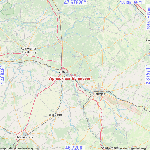
Vignoux-sur-Barangeon GPS coordinates[2]
47° 12' 2.448" North, 2° 10' 21.288" East
| Map corner | latitude | longitude |
|---|---|---|
| Upper-left | 47.67626°, | 1.46946° |
| Center: | 47.20068°, | 2.17258° |
| Lower-right: | 46.7208°, | 2.87571° |
| Map W x H: | 106.2×106.2 km | = 66×66mi |
| max Lat: | 51.07786° ⇑53% North |
| Vignoux-sur-Barangeon: | 47.20068° |
| min Lat: | ⇓47% South 41.3874° |
| min Long | Vignoux-sur-Bar | max Long |
| -5.08615° | 2.17258° | 9.52242° |
| W 45.2%⇐ | ⇒54.8% E |
Elevation
Elevation of Vignoux-sur-Barangeon is 109 m = 358 ft, and this is 84.7 m = 278 ft below average elevation for this country.
| Max E: |
2333 m = 7654 ft | 57.6% |
| Avg. | 193.7 m = 635 ft | |
| Vignoux-sur-Barangeon | 109 m = 358 ft | |
Min E: |
-1 m = -3 ft | 42.4% |
See also: France elevation on elevation.city.
Geographical zone
Vignoux-sur-Barangeon is located in North temperate zone (between Tropic of Cancer and the Arctic Circle). Distance of this North polar circle is 2153 km =1337.8 mi to North.| Distance of | km | miles | from Vignoux-sur-Barangeon |
|---|---|---|---|
| North Pole | 4758.8 | 2957 | to North |
| Arctic Circle | 2153 | 1337.8 | to North |
| Tropic Cancer | 2642.3 | 1641.8 | to South |
| Equator | 5248.2 | 3261.1 | to South |


Nearby cities:
15 places around Vignoux-sur-Barangeon: (largest is in red/bold)
• Allogny
11.5 km =7.1 mi,  76°
76°
• Allouis
5.7 km =3.5 mi,  133°
133°
• Berry-Bouy
13.4 km =8.3 mi,  138°
138°
• Foëcy
2.8 km =1.7 mi,  195°
195°
• Lury-sur-Arnon
11.9 km =7.4 mi,  226°
226°
• Marmagne
14 km =8.7 mi, 143°
• Massay
14.5 km =9 mi,  248°
248°
• Mehun-sur-Yèvre
7.6 km =4.7 mi,  157°
157°
• Méreau
10.1 km =6.3 mi, 245°
• Neuvy-sur-Barangeon
14.1 km =8.8 mi,  25°
25°
• Quincy
7.6 km =4.7 mi,  188°
188°
• Saint-Hilaire-de-Court
11.6 km =7.2 mi,  272°
272°
• Saint-Éloy-de-Gy
13.8 km =8.6 mi,  111°
111°
• Vierzon
8.2 km =5.1 mi,  286°
286°
• Vouzeron
7.6 km =4.7 mi, 29°
Sources, notices
• [Note1] Compared only with cities in France existing in our database
• [Src1] Map data: © OpenStreetMap contributors (CC-BY-SA)
• [Src2] Other city data from geonames.org with taken over terms of usage.
• [Src3] Geographical zone / Annual Mean Temperature by Robert A. Rohde @ Wikipedia
