Vendeuvre-sur-Barse geodata
Vendeuvre-sur-Barse (Grand Est) is a populated place; located in France in Europe/Paris (GMT+2) time zone. With population of 2,703 people, there are 3614 cities with bigger population in this country. Compared to other cities in France, 63.5% of cities are located further ↓South; 71.8% of cities are located further ←West and 56.8% of cities have lower elevation than Vendeuvre-sur-Barse. Note1
Administrative division(s):
- Level 1: Grand Est
- Level 2: Département de l'Aube
- Level 3: Arrondissement de Bar-sur-Aube
- Level 4: Vendeuvre-sur-Barse


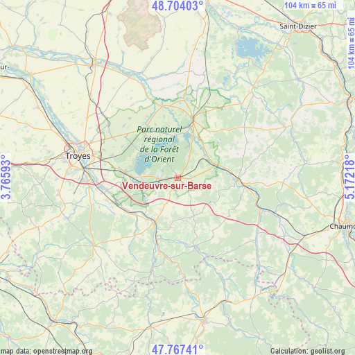
Vendeuvre-sur-Barse GPS coordinates[2]
48° 14' 16.296" North, 4° 28' 8.58" East
| Map corner | latitude | longitude |
|---|---|---|
| Upper-left | 48.70403°, | 3.76593° |
| Center: | 48.23786°, | 4.46905° |
| Lower-right: | 47.76741°, | 5.17218° |
| Map W x H: | 104.1×104.1 km | = 64.7×64.7mi |
| max Lat: | 51.07786° ⇑36.5% North |
| Vendeuvre-sur-Barse: | 48.23786° |
| min Lat: | ⇓63.5% South 41.3874° |
| min Long | Vendeuvre-sur-B | max Long |
| -5.08615° | 4.46905° | 9.52242° |
| W 71.8%⇐ | ⇒28.2% E |
Elevation
Elevation of Vendeuvre-sur-Barse is 157 m = 515 ft, and this is 36.7 m = 120 ft below average elevation for this country.
| Max E: |
2333 m = 7654 ft | 43.2% |
| Avg. | 193.7 m = 635 ft | |
| Vendeuvre-sur-Barse | 157 m = 515 ft | |
Min E: |
-1 m = -3 ft | 56.8% |
See also: France elevation on elevation.city.
Geographical zone
Vendeuvre-sur-Barse is located in North temperate zone (between Tropic of Cancer and the Arctic Circle). Distance of this North polar circle is 2037.6 km =1266.1 mi to North.| Distance of | km | miles | from Vendeuvre-sur-Barse |
|---|---|---|---|
| North Pole | 4643.5 | 2885.3 | to North |
| Arctic Circle | 2037.6 | 1266.1 | to North |
| Tropic Cancer | 2757.6 | 1713.5 | to South |
| Equator | 5363.5 | 3332.7 | to South |


Nearby cities:
15 places around Vendeuvre-sur-Barse: (largest is in red/bold)
• Bar-sur-Aube
17.6 km =10.9 mi,  91°
91°
• Bar-sur-Seine
15.5 km =9.6 mi,  206°
206°
• Brienne-le-Château
17.8 km =11.1 mi,  13°
13°
• Brévonnes
14.4 km =8.9 mi,  339°
339°
• Clérey
20.8 km =12.9 mi,  261°
261°
• Dienville
13.3 km =8.3 mi,  20°
20°
• Essoyes
20.7 km =12.9 mi,  166°
166°
• Landreville
18.3 km =11.4 mi,  179°
179°
• Lusigny-sur-Barse
14.9 km =9.3 mi,  277°
277°
• Montaulin
20.3 km =12.6 mi,  274°
274°
• Piney
17.2 km =10.7 mi,  324°
324°
• Saint-Parres-lès-Vaudes
20.1 km =12.5 mi,  248°
248°
• Vaudes
21.8 km =13.5 mi, 252°
• Villemoyenne
19.1 km =11.9 mi, 249°
• Virey-sous-Bar
16 km =9.9 mi,  227°
227°
Sources, notices
• [Note1] Compared only with cities in France existing in our database
• [Src1] Map data: © OpenStreetMap contributors (CC-BY-SA)
• [Src2] Other city data from geonames.org with taken over terms of usage.
• [Src3] Geographical zone / Annual Mean Temperature by Robert A. Rohde @ Wikipedia
