Espinasse-Vozelle geodata
Espinasse-Vozelle (Auvergne-Rhône-Alpes) is a populated place; located in France in Europe/Paris (GMT+2) time zone. With population of 818 people, there are 10409 cities with bigger population in this country. Compared to other cities in France, 64.7% of cities are located further ↑North; 62.3% of cities are located further ←West and 82.2% of cities have lower elevation than Espinasse-Vozelle. Note1
Administrative division(s):
- Level 1: Auvergne-Rhône-Alpes
- Level 2: Département de l'Allier
- Level 3: Arrondissement de Vichy
- Level 4: Espinasse-Vozelle


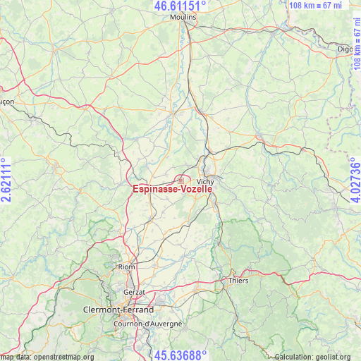
Espinasse-Vozelle GPS coordinates[2]
46° 7' 34.86" North, 3° 19' 27.264" East
| Map corner | latitude | longitude |
|---|---|---|
| Upper-left | 46.61151°, | 2.62111° |
| Center: | 46.12635°, | 3.32424° |
| Lower-right: | 45.63688°, | 4.02736° |
| Map W x H: | 108.4×108.4 km | = 67.4×67.4mi |
| max Lat: | 51.07786° ⇑64.7% North |
| Espinasse-Vozelle: | 46.12635° |
| min Lat: | ⇓35.3% South 41.3874° |
| min Long | Espinasse-Vozel | max Long |
| -5.08615° | 3.32424° | 9.52242° |
| W 62.3%⇐ | ⇒37.7% E |
Elevation
Elevation of Espinasse-Vozelle is 312 m = 1024 ft, and this is 118.3 m = 388 ft above average elevation for this country.
| Max E: |
2333 m = 7654 ft | 17.8% |
| Espinasse-Vozelle | 312 m 1024 ft | |
| Avg. | 193.7 m = 635 ft | |
Min E: |
-1 m = -3 ft | 82.2% |
See also: France elevation on elevation.city.
Geographical zone
Espinasse-Vozelle is located in North temperate zone (between Tropic of Cancer and the Arctic Circle). Distance of this North polar circle is 2272.4 km =1412 mi to North.| Distance of | km | miles | from Espinasse-Vozelle |
|---|---|---|---|
| North Pole | 4878.3 | 3031.2 | to North |
| Arctic Circle | 2272.4 | 1412 | to North |
| Tropic Cancer | 2522.9 | 1567.7 | to South |
| Equator | 5128.8 | 3186.9 | to South |


Nearby cities:
15 places around Espinasse-Vozelle: (largest is in red/bold)
• Abrest
9.8 km =6.1 mi,  108°
108°
• Bellerive-sur-Allier
6.2 km =3.9 mi,  100°
100°
• Biozat
6.8 km =4.2 mi,  215°
215°
• Broût-Vernet
7.9 km =4.9 mi,  330°
330°
• Brugheas
6.5 km =4 mi,  148°
148°
• Charmeil
6.6 km =4.1 mi,  53°
53°
• Cognat-Lyonne
2.3 km =1.4 mi,  208°
208°
• Creuzier-le-Vieux
9.3 km =5.8 mi,  64°
64°
• Escurolles
4.9 km =3 mi,  292°
292°
• Gannat
10.1 km =6.3 mi,  253°
253°
• Pragoulin
9.6 km =6 mi, 146°
• Saint-Rémy-en-Rollat
8.2 km =5.1 mi,  39°
39°
• Serbannes
4.1 km =2.5 mi,  139°
139°
• Vendat
4.7 km =2.9 mi,  28°
28°
• Vichy
7.8 km =4.8 mi,  89°
89°
Sources, notices
• [Note1] Compared only with cities in France existing in our database
• [Src1] Map data: © OpenStreetMap contributors (CC-BY-SA)
• [Src2] Other city data from geonames.org with taken over terms of usage.
• [Src3] Geographical zone / Annual Mean Temperature by Robert A. Rohde @ Wikipedia
