Vélizy-Villacoublay geodata
Vélizy-Villacoublay (Île-de-France) is a populated place; located in France in Europe/Paris (GMT+2) time zone. With population of 21,741 people, there are 413 cities with bigger population in this country. Compared to other cities in France, 75.1% of cities are located further ↓South; 54.5% of cities are located further →East and 62.1% of cities have lower elevation than Vélizy-Villacoublay. Note1
Administrative division(s):
- Level 1: Île-de-France
- Level 2: Yvelines
- Level 3: Arrondissement de Versailles
- Level 4: Vélizy-Villacoublay


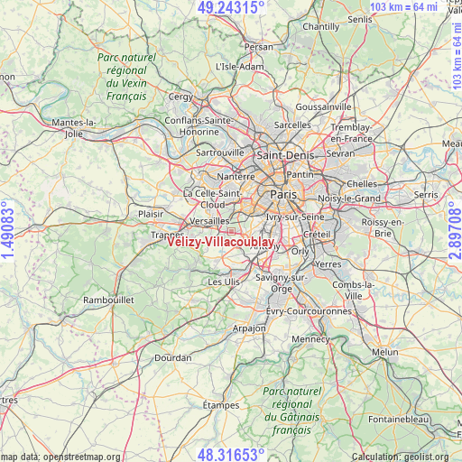
Vélizy-Villacoublay GPS coordinates[2]
48° 46' 55.128" North, 2° 11' 38.22" East
| Map corner | latitude | longitude |
|---|---|---|
| Upper-left | 49.24315°, | 1.49083° |
| Center: | 48.78198°, | 2.19395° |
| Lower-right: | 48.31653°, | 2.89708° |
| Map W x H: | 103×103 km | = 64×64mi |
| max Lat: | 51.07786° ⇑24.9% North |
| Vélizy-Villacoublay: | 48.78198° |
| min Lat: | ⇓75.1% South 41.3874° |
| min Long | Vélizy-Villaco | max Long |
| -5.08615° | 2.19395° | 9.52242° |
| W 45.5%⇐ | ⇒54.5% E |
Elevation
Elevation of Vélizy-Villacoublay is 180 m = 591 ft, and this is 13.7 m = 45 ft below average elevation for this country.
| Max E: |
2333 m = 7654 ft | 37.9% |
| Avg. | 193.7 m = 635 ft | |
| Vélizy-Villacoublay | 180 m = 591 ft | |
Min E: |
-1 m = -3 ft | 62.1% |
See also: France elevation on elevation.city.
Geographical zone
Vélizy-Villacoublay is located in North temperate zone (between Tropic of Cancer and the Arctic Circle). Distance of this North polar circle is 1977.1 km =1228.5 mi to North.| Distance of | km | miles | from Vélizy-Villacoublay |
|---|---|---|---|
| North Pole | 4583 | 2847.7 | to North |
| Arctic Circle | 1977.1 | 1228.5 | to North |
| Tropic Cancer | 2818.1 | 1751.1 | to South |
| Equator | 5424 | 3370.3 | to South |


Nearby cities:
15 places around Vélizy-Villacoublay: (largest is in red/bold)
• Bièvres
3.3 km =2.1 mi,  145°
145°
• Buc
5 km =3.1 mi,  262°
262°
• Chaville
2.7 km =1.7 mi,  351°
351°
• Châtenay-Malabry
5.6 km =3.5 mi,  109°
109°
• Igny
4.7 km =2.9 mi, 152°
• Jouy-en-Josas
3.1 km =1.9 mi,  214°
214°
• Le Plessis-Robinson
5.7 km =3.5 mi,  82°
82°
• Les Loges-en-Josas
4.4 km =2.7 mi,  242°
242°
• Marnes-la-Coquette
5.3 km =3.3 mi,  341°
341°
• Meudon
4.6 km =2.9 mi,  40°
40°
• Sèvres
4.9 km =3 mi,  20°
20°
• Vauhallan
5.4 km =3.4 mi,  173°
173°
• Versailles
5 km =3.1 mi,  298°
298°
• Ville-d’Avray
4.6 km =2.9 mi,  359°
359°
• Viroflay
3.1 km =1.9 mi,  311°
311°
Sources, notices
• [Note1] Compared only with cities in France existing in our database
• [Src1] Map data: © OpenStreetMap contributors (CC-BY-SA)
• [Src2] Other city data from geonames.org with taken over terms of usage.
• [Src3] Geographical zone / Annual Mean Temperature by Robert A. Rohde @ Wikipedia
