Viroflay geodata
Viroflay (Île-de-France) is a populated place; located in France in Europe/Paris (GMT+2) time zone. With population of 16,137 people, there are 588 cities with bigger population in this country. Compared to other cities in France, 75.6% of cities are located further ↓South; 55% of cities are located further →East and 57.3% of cities have higher elevation than Viroflay. Note1
Administrative division(s):
- Level 1: Île-de-France
- Level 2: Yvelines
- Level 3: Arrondissement de Versailles
- Level 4: Viroflay


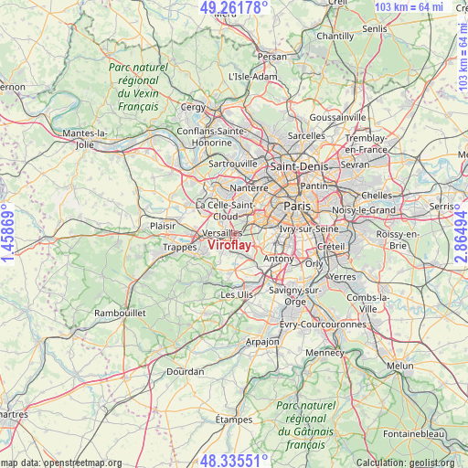
Viroflay GPS coordinates[2]
48° 48' 2.808" North, 2° 9' 42.516" East
| Map corner | latitude | longitude |
|---|---|---|
| Upper-left | 49.26178°, | 1.45869° |
| Center: | 48.80078°, | 2.16181° |
| Lower-right: | 48.33551°, | 2.86494° |
| Map W x H: | 103×103 km | = 64×64mi |
| max Lat: | 51.07786° ⇑24.4% North |
| Viroflay: | 48.80078° |
| min Lat: | ⇓75.6% South 41.3874° |
| min Long | Viroflay | max Long |
| -5.08615° | 2.16181° | 9.52242° |
| W 45%⇐ | ⇒55% E |
Elevation
Elevation of Viroflay is 110 m = 361 ft, and this is 83.7 m = 275 ft below average elevation for this country.
| Max E: |
2333 m = 7654 ft | 57.3% |
| Avg. | 193.7 m = 635 ft | |
| Viroflay | 110 m = 361 ft | |
Min E: |
-1 m = -3 ft | 42.7% |
See also: France elevation on elevation.city.
Geographical zone
Viroflay is located in North temperate zone (between Tropic of Cancer and the Arctic Circle). Distance of this North polar circle is 1975 km =1227.2 mi to North.| Distance of | km | miles | from Viroflay |
|---|---|---|---|
| North Pole | 4580.9 | 2846.4 | to North |
| Arctic Circle | 1975 | 1227.2 | to North |
| Tropic Cancer | 2820.2 | 1752.4 | to South |
| Equator | 5426.1 | 3371.6 | to South |


Nearby cities:
15 places around Viroflay: (largest is in red/bold)
• Buc
3.8 km =2.4 mi,  224°
224°
• Chaville
2 km =1.2 mi,  74°
74°
• Garches
4.9 km =3 mi,  18°
18°
• Jouy-en-Josas
4.7 km =2.9 mi,  172°
172°
• La Celle-Saint-Cloud
5.6 km =3.5 mi,  347°
347°
• Le Chesnay
3.8 km =2.4 mi,  309°
309°
• Les Loges-en-Josas
4.4 km =2.7 mi,  201°
201°
• Marnes-la-Coquette
3 km =1.9 mi,  13°
13°
• Meudon
5.6 km =3.5 mi, 74°
• Saint-Cloud
5.9 km =3.7 mi,  30°
30°
• Sèvres
4.8 km =3 mi,  58°
58°
• Vaucresson
4.5 km =2.8 mi,  355°
355°
• Versailles
2 km =1.2 mi,  278°
278°
• Ville-d’Avray
3.4 km =2.1 mi,  42°
42°
• Vélizy-Villacoublay
3.1 km =1.9 mi,  131°
131°
Sources, notices
• [Note1] Compared only with cities in France existing in our database
• [Src1] Map data: © OpenStreetMap contributors (CC-BY-SA)
• [Src2] Other city data from geonames.org with taken over terms of usage.
• [Src3] Geographical zone / Annual Mean Temperature by Robert A. Rohde @ Wikipedia
