Sèvres geodata
Sèvres (Île-de-France) is a populated place; located in France in Europe/Paris (GMT+2) time zone. With population of 23,724 people, there are 373 cities with bigger population in this country. Compared to other cities in France, 76.1% of cities are located further ↓South; 54.1% of cities are located further →East and 64% of cities have higher elevation than Sèvres. Note1
Administrative division(s):
- Level 1: Île-de-France
- Level 2: Hauts-de-Seine
- Level 3: Arrondissement de Boulogne-Billancourt
- Level 4: Sèvres


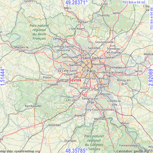
Sèvres GPS coordinates[2]
48° 49' 22.512" North, 2° 13' 3.252" East
| Map corner | latitude | longitude |
|---|---|---|
| Upper-left | 49.28371°, | 1.51444° |
| Center: | 48.82292°, | 2.21757° |
| Lower-right: | 48.35785°, | 2.92069° |
| Map W x H: | 102.9×102.9 km | = 63.9×63.9mi |
| max Lat: | 51.07786° ⇑23.9% North |
| Sèvres: | 48.82292° |
| min Lat: | ⇓76.1% South 41.3874° |
| min Long | Sèvres | max Long |
| -5.08615° | 2.21757° | 9.52242° |
| W 45.9%⇐ | ⇒54.1% E |
Elevation
Elevation of Sèvres is 92 m = 302 ft, and this is 101.7 m = 334 ft below average elevation for this country.
| Max E: |
2333 m = 7654 ft | 64% |
| Avg. | 193.7 m = 635 ft | |
| Sèvres | 92 m = 302 ft | |
Min E: |
-1 m = -3 ft | 36% |
See also: France elevation on elevation.city.
Geographical zone
Sèvres is located in North temperate zone (between Tropic of Cancer and the Arctic Circle). Distance of this North polar circle is 1972.6 km =1225.7 mi to North.| Distance of | km | miles | from Sèvres |
|---|---|---|---|
| North Pole | 4578.5 | 2844.9 | to North |
| Arctic Circle | 1972.6 | 1225.7 | to North |
| Tropic Cancer | 2822.7 | 1753.9 | to South |
| Equator | 5428.6 | 3373.2 | to South |


Nearby cities:
15 places around Sèvres: (largest is in red/bold)
• Boulogne-Billancourt
2.2 km =1.4 mi,  51°
51°
• Chaville
2.9 km =1.8 mi,  227°
227°
• Clamart
4.2 km =2.6 mi,  121°
121°
• Garches
3.4 km =2.1 mi,  309°
309°
• Issy-les-Moulineaux
4.4 km =2.7 mi,  92°
92°
• Le Plessis-Robinson
5.4 km =3.4 mi,  134°
134°
• Marnes-la-Coquette
3.4 km =2.1 mi,  278°
278°
• Meudon
1.6 km =1 mi, 128°
• Saint-Cloud
2.8 km =1.7 mi,  337°
337°
• Suresnes
5.5 km =3.4 mi,  9°
9°
• Vanves
5.3 km =3.3 mi, 89°
• Vaucresson
4.9 km =3 mi,  293°
293°
• Ville-d’Avray
1.8 km =1.1 mi,  272°
272°
• Viroflay
4.8 km =3 mi,  238°
238°
• Vélizy-Villacoublay
4.9 km =3 mi,  200°
200°
Sources, notices
• [Note1] Compared only with cities in France existing in our database
• [Src1] Map data: © OpenStreetMap contributors (CC-BY-SA)
• [Src2] Other city data from geonames.org with taken over terms of usage.
• [Src3] Geographical zone / Annual Mean Temperature by Robert A. Rohde @ Wikipedia
