Sainte-Geneviève geodata
Sainte-Geneviève (Hauts-de-France) is a populated place; located in France in Europe/Paris (GMT+2) time zone. With population of 2,682 people, there are 3637 cities with bigger population in this country. Compared to other cities in France, 85.8% of cities are located further ↓South; 54.5% of cities are located further →East and 66.8% of cities have lower elevation than Sainte-Geneviève. Note1
Administrative division(s):
- Level 1: Hauts-de-France
- Level 2: Département de l'Oise
- Level 3: Arrondissement de Beauvais
- Level 4: Sainte-Geneviève


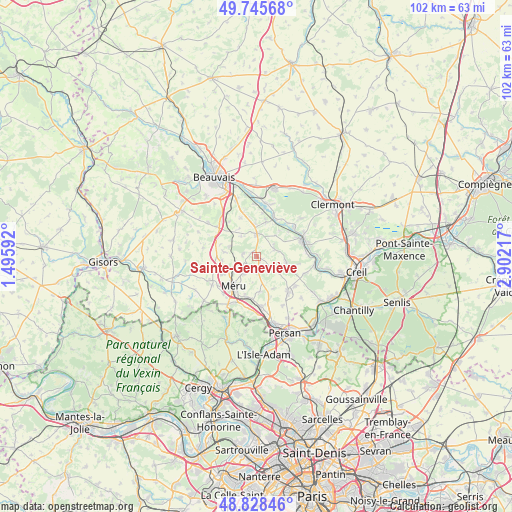
Sainte-Geneviève GPS coordinates[2]
49° 17' 21.12" North, 2° 11' 56.544" East
| Map corner | latitude | longitude |
|---|---|---|
| Upper-left | 49.74568°, | 1.49592° |
| Center: | 49.2892°, | 2.19904° |
| Lower-right: | 48.82846°, | 2.90217° |
| Map W x H: | 102×102 km | = 63.4×63.4mi |
| max Lat: | 51.07786° ⇑14.2% North |
| Sainte-Geneviève: | 49.2892° |
| min Lat: | ⇓85.8% South 41.3874° |
| min Long | Sainte-Geneviè | max Long |
| -5.08615° | 2.19904° | 9.52242° |
| W 45.5%⇐ | ⇒54.5% E |
Elevation
Elevation of Sainte-Geneviève is 203 m = 666 ft, and this is 9.3 m = 31 ft above average elevation for this country.
| Max E: |
2333 m = 7654 ft | 33.2% |
| Sainte-Geneviève | 203 m 666 ft | |
| Avg. | 193.7 m = 635 ft | |
Min E: |
-1 m = -3 ft | 66.8% |
See also: France elevation on elevation.city.
Geographical zone
Sainte-Geneviève is located in North temperate zone (between Tropic of Cancer and the Arctic Circle). Distance of this North polar circle is 1920.7 km =1193.5 mi to North.| Distance of | km | miles | from Sainte-Geneviève |
|---|---|---|---|
| North Pole | 4526.6 | 2812.7 | to North |
| Arctic Circle | 1920.7 | 1193.5 | to North |
| Tropic Cancer | 2874.5 | 1786.1 | to South |
| Equator | 5480.4 | 3405.4 | to South |


Nearby cities:
15 places around Sainte-Geneviève: (largest is in red/bold)
• Andeville
4 km =2.5 mi,  218°
218°
• Berthecourt
7.1 km =4.4 mi,  15°
15°
• Cauvigny
3.8 km =2.4 mi,  68°
68°
• Esches
8 km =5 mi,  197°
197°
• Heilles
7 km =4.3 mi,  43°
43°
• Laboissière-en-Thelle
2.8 km =1.7 mi,  279°
279°
• Lachapelle-Saint-Pierre
3.4 km =2.1 mi,  129°
129°
• Le Coudray-sur-Thelle
5.7 km =3.5 mi,  288°
288°
• Lormaison
7.7 km =4.8 mi,  241°
241°
• Mortefontaine-en-Thelle
2.9 km =1.8 mi, 196°
• Méru
7.8 km =4.8 mi, 217°
• Noailles
4.4 km =2.7 mi,  1°
1°
• Ponchon
6.4 km =4 mi,  358°
358°
• Puiseux-le-Hauberger
8.5 km =5.3 mi,  161°
161°
• Ully-Saint-Georges
6 km =3.7 mi,  100°
100°
Sources, notices
• [Note1] Compared only with cities in France existing in our database
• [Src1] Map data: © OpenStreetMap contributors (CC-BY-SA)
• [Src2] Other city data from geonames.org with taken over terms of usage.
• [Src3] Geographical zone / Annual Mean Temperature by Robert A. Rohde @ Wikipedia
