Cauvigny geodata
Cauvigny (Hauts-de-France) is a populated place; located in France in Europe/Paris (GMT+2) time zone. With population of 1,251 people, there are 7273 cities with bigger population in this country. Compared to other cities in France, 86.1% of cities are located further ↓South; 53.5% of cities are located further →East and 68.3% of cities have higher elevation than Cauvigny. Note1
Administrative division(s):
- Level 1: Hauts-de-France
- Level 2: Département de l'Oise
- Level 3: Arrondissement de Beauvais
- Level 4: Cauvigny


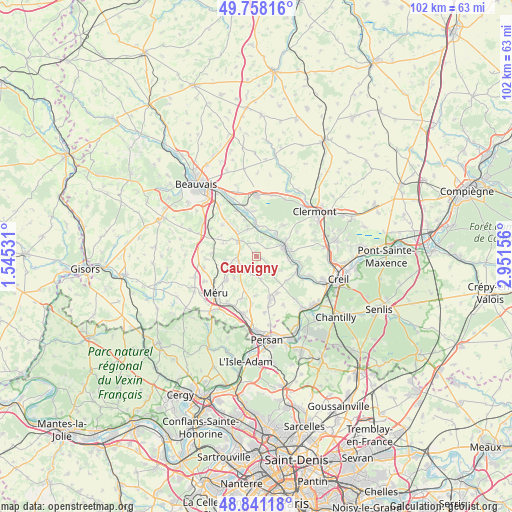
Cauvigny GPS coordinates[2]
49° 18' 6.48" North, 2° 14' 54.384" East
| Map corner | latitude | longitude |
|---|---|---|
| Upper-left | 49.75816°, | 1.54531° |
| Center: | 49.3018°, | 2.24844° |
| Lower-right: | 48.84118°, | 2.95156° |
| Map W x H: | 102×102 km | = 63.4×63.4mi |
| max Lat: | 51.07786° ⇑13.9% North |
| Cauvigny: | 49.3018° |
| min Lat: | ⇓86.1% South 41.3874° |
| min Long | Cauvigny | max Long |
| -5.08615° | 2.24844° | 9.52242° |
| W 46.5%⇐ | ⇒53.5% E |
Elevation
Elevation of Cauvigny is 82 m = 269 ft, and this is 111.7 m = 366 ft below average elevation for this country.
| Max E: |
2333 m = 7654 ft | 68.3% |
| Avg. | 193.7 m = 635 ft | |
| Cauvigny | 82 m = 269 ft | |
Min E: |
-1 m = -3 ft | 31.7% |
See also: France elevation on elevation.city.
Geographical zone
Cauvigny is located in North temperate zone (between Tropic of Cancer and the Arctic Circle). Distance of this North polar circle is 1919.3 km =1192.6 mi to North.| Distance of | km | miles | from Cauvigny |
|---|---|---|---|
| North Pole | 4525.2 | 2811.8 | to North |
| Arctic Circle | 1919.3 | 1192.6 | to North |
| Tropic Cancer | 2875.9 | 1787 | to South |
| Equator | 5481.8 | 3406.2 | to South |


Nearby cities:
15 places around Cauvigny: (largest is in red/bold)
• Angy
6.6 km =4.1 mi,  61°
61°
• Balagny-sur-Thérain
6.4 km =4 mi,  95°
95°
• Berthecourt
5.7 km =3.5 mi,  342°
342°
• Heilles
3.9 km =2.4 mi,  18°
18°
• Hermes
6.5 km =4 mi,  357°
357°
• Hondainville
5.8 km =3.6 mi,  41°
41°
• Laboissière-en-Thelle
6.4 km =4 mi,  261°
261°
• Lachapelle-Saint-Pierre
3.7 km =2.3 mi,  194°
194°
• Mortefontaine-en-Thelle
6.1 km =3.8 mi,  226°
226°
• Mouy
5.4 km =3.4 mi,  73°
73°
• Noailles
4.6 km =2.9 mi,  310°
310°
• Ponchon
6.2 km =3.9 mi,  323°
323°
• Saint-Félix
6.7 km =4.2 mi, 21°
• Sainte-Geneviève
3.8 km =2.4 mi,  248°
248°
• Ully-Saint-Georges
3.5 km =2.2 mi,  136°
136°
Sources, notices
• [Note1] Compared only with cities in France existing in our database
• [Src1] Map data: © OpenStreetMap contributors (CC-BY-SA)
• [Src2] Other city data from geonames.org with taken over terms of usage.
• [Src3] Geographical zone / Annual Mean Temperature by Robert A. Rohde @ Wikipedia
