Trémeur geodata
Trémeur (Brittany) is a populated place; located in France in Europe/Paris (GMT+2) time zone. With population of 660 people, there are 12381 cities with bigger population in this country. Compared to other cities in France, 65.4% of cities are located further ↓South; 95.7% of cities are located further →East and 80.2% of cities have higher elevation than Trémeur. Note1
Administrative division(s):
- Level 1: Brittany
- Level 2: Département des Côtes-d’Armor
- Level 3: Arrondissement de Saint-Brieuc
- Level 4: Trémeur


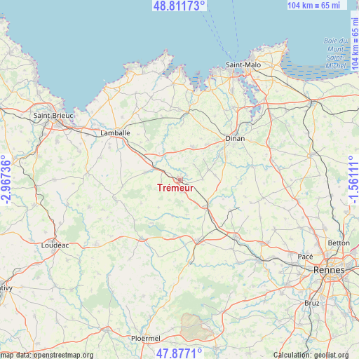
Trémeur GPS coordinates[2]
48° 20' 47.616" North, 2° 15' 51.228" West
| Map corner | latitude | longitude |
|---|---|---|
| Upper-left | 48.81173°, | -2.96736° |
| Center: | 48.34656°, | -2.26423° |
| Lower-right: | 47.8771°, | -1.56111° |
| Map W x H: | 103.9×103.9 km | = 64.6×64.6mi |
| max Lat: | 51.07786° ⇑34.6% North |
| Trémeur: | 48.34656° |
| min Lat: | ⇓65.4% South 41.3874° |
| min Long | Trémeur | max Long |
| -5.08615° | -2.26423° | 9.52242° |
| W 4.3%⇐ | ⇒95.7% E |
Elevation
Elevation of Trémeur is 54 m = 177 ft, and this is 139.7 m = 458 ft below average elevation for this country.
| Max E: |
2333 m = 7654 ft | 80.2% |
| Avg. | 193.7 m = 635 ft | |
| Trémeur | 54 m = 177 ft | |
Min E: |
-1 m = -3 ft | 19.8% |
See also: France elevation on elevation.city.
Geographical zone
Trémeur is located in North temperate zone (between Tropic of Cancer and the Arctic Circle). Distance of this North polar circle is 2025.5 km =1258.6 mi to North.| Distance of | km | miles | from Trémeur |
|---|---|---|---|
| North Pole | 4631.4 | 2877.8 | to North |
| Arctic Circle | 2025.5 | 1258.6 | to North |
| Tropic Cancer | 2769.7 | 1721 | to South |
| Equator | 5375.6 | 3340.2 | to South |


Nearby cities:
15 places around Trémeur: (largest is in red/bold)
• Broons
3.3 km =2.1 mi,  173°
173°
• Brusvily
11.2 km =7 mi,  64°
64°
• Caulnes
10.4 km =6.5 mi,  128°
128°
• Jugon-les-Lacs
9.3 km =5.8 mi,  326°
326°
• Lanrelas
11.1 km =6.9 mi,  193°
193°
• Mégrit
3.3 km =2.1 mi,  19°
19°
• Plumaudan
10.4 km =6.5 mi,  83°
83°
• Plumaugat
10.4 km =6.5 mi, 169°
• Plélan-le-Petit
10.1 km =6.3 mi, 20°
• Plénée-Jugon
10.3 km =6.4 mi,  281°
281°
• Sévignac
5.7 km =3.5 mi,  254°
254°
• Tramain
11.8 km =7.3 mi,  300°
300°
• Vildé-Guingalan
12.8 km =8 mi,  37°
37°
• Yvignac-la-Tour
6 km =3.7 mi,  86°
86°
• Éréac
10.1 km =6.3 mi,  217°
217°
Sources, notices
• [Note1] Compared only with cities in France existing in our database
• [Src1] Map data: © OpenStreetMap contributors (CC-BY-SA)
• [Src2] Other city data from geonames.org with taken over terms of usage.
• [Src3] Geographical zone / Annual Mean Temperature by Robert A. Rohde @ Wikipedia
