Broons geodata
Broons (Brittany) is a populated place; located in France in Europe/Paris (GMT+2) time zone. With population of 2,542 people, there are 3838 cities with bigger population in this country. Compared to other cities in France, 64.9% of cities are located further ↓South; 95.7% of cities are located further →East and 62.8% of cities have higher elevation than Broons. Note1
Administrative division(s):
- Level 1: Brittany
- Level 2: Département des Côtes-d’Armor
- Level 3: Arrondissement de Dinan
- Level 4: Broons


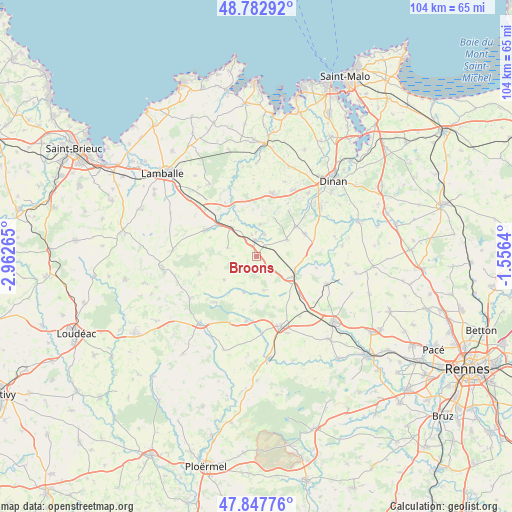
Broons GPS coordinates[2]
48° 19' 2.928" North, 2° 15' 34.272" West
| Map corner | latitude | longitude |
|---|---|---|
| Upper-left | 48.78292°, | -2.96265° |
| Center: | 48.31748°, | -2.25952° |
| Lower-right: | 47.84776°, | -1.5564° |
| Map W x H: | 104×104 km | = 64.6×64.6mi |
| max Lat: | 51.07786° ⇑35.1% North |
| Broons: | 48.31748° |
| min Lat: | ⇓64.9% South 41.3874° |
| min Long | Broons | max Long |
| -5.08615° | -2.25952° | 9.52242° |
| W 4.3%⇐ | ⇒95.7% E |
Elevation
Elevation of Broons is 95 m = 312 ft, and this is 98.7 m = 324 ft below average elevation for this country.
| Max E: |
2333 m = 7654 ft | 62.8% |
| Avg. | 193.7 m = 635 ft | |
| Broons | 95 m = 312 ft | |
Min E: |
-1 m = -3 ft | 37.2% |
See also: France elevation on elevation.city.
Geographical zone
Broons is located in North temperate zone (between Tropic of Cancer and the Arctic Circle). Distance of this North polar circle is 2028.8 km =1260.6 mi to North.| Distance of | km | miles | from Broons |
|---|---|---|---|
| North Pole | 4634.7 | 2879.9 | to North |
| Arctic Circle | 2028.8 | 1260.6 | to North |
| Tropic Cancer | 2766.5 | 1719 | to South |
| Equator | 5372.4 | 3338.3 | to South |


Nearby cities:
15 places around Broons: (largest is in red/bold)
• Brusvily
12.7 km =7.9 mi,  50°
50°
• Caulnes
8.4 km =5.2 mi,  112°
112°
• Guitté
12.4 km =7.7 mi,  100°
100°
• Jugon-les-Lacs
12.3 km =7.6 mi,  333°
333°
• Langourla
12.1 km =7.5 mi,  252°
252°
• Lanrelas
8.1 km =5 mi,  201°
201°
• Mégrit
6.4 km =4 mi,  7°
7°
• Plumaudan
10.9 km =6.8 mi,  65°
65°
• Plumaugat
7.1 km =4.4 mi,  167°
167°
• Plénée-Jugon
11.7 km =7.3 mi,  296°
296°
• Quédillac
11.5 km =7.1 mi,  131°
131°
• Sévignac
6.1 km =3.8 mi,  286°
286°
• Trémeur
3.3 km =2.1 mi,  353°
353°
• Yvignac-la-Tour
6.7 km =4.2 mi,  57°
57°
• Éréac
8.1 km =5 mi,  233°
233°
Sources, notices
• [Note1] Compared only with cities in France existing in our database
• [Src1] Map data: © OpenStreetMap contributors (CC-BY-SA)
• [Src2] Other city data from geonames.org with taken over terms of usage.
• [Src3] Geographical zone / Annual Mean Temperature by Robert A. Rohde @ Wikipedia
