Plumaudan geodata
Plumaudan (Brittany) is a populated place; located in France in Europe/Paris (GMT+2) time zone. With population of 953 people, there are 9182 cities with bigger population in this country. Compared to other cities in France, 65.6% of cities are located further ↓South; 95.3% of cities are located further →East and 69.2% of cities have higher elevation than Plumaudan. Note1
Administrative division(s):
- Level 1: Brittany
- Level 2: Département des Côtes-d’Armor
- Level 3: Arrondissement de Dinan
- Level 4: Plumaudan


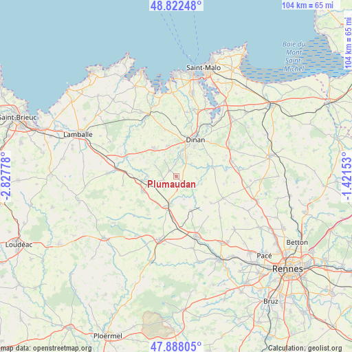
Plumaudan GPS coordinates[2]
48° 21' 26.676" North, 2° 7' 28.74" West
| Map corner | latitude | longitude |
|---|---|---|
| Upper-left | 48.82248°, | -2.82778° |
| Center: | 48.35741°, | -2.12465° |
| Lower-right: | 47.88805°, | -1.42153° |
| Map W x H: | 103.9×103.9 km | = 64.6×64.6mi |
| max Lat: | 51.07786° ⇑34.4% North |
| Plumaudan: | 48.35741° |
| min Lat: | ⇓65.6% South 41.3874° |
| min Long | Plumaudan | max Long |
| -5.08615° | -2.12465° | 9.52242° |
| W 4.7%⇐ | ⇒95.3% E |
Elevation
Elevation of Plumaudan is 80 m = 262 ft, and this is 113.7 m = 373 ft below average elevation for this country.
| Max E: |
2333 m = 7654 ft | 69.2% |
| Avg. | 193.7 m = 635 ft | |
| Plumaudan | 80 m = 262 ft | |
Min E: |
-1 m = -3 ft | 30.8% |
See also: France elevation on elevation.city.
Geographical zone
Plumaudan is located in North temperate zone (between Tropic of Cancer and the Arctic Circle). Distance of this North polar circle is 2024.3 km =1257.8 mi to North.| Distance of | km | miles | from Plumaudan |
|---|---|---|---|
| North Pole | 4630.2 | 2877.1 | to North |
| Arctic Circle | 2024.3 | 1257.8 | to North |
| Tropic Cancer | 2770.9 | 1721.8 | to South |
| Equator | 5376.8 | 3341 | to South |


Nearby cities:
15 places around Plumaudan: (largest is in red/bold)
• Bobital
6.7 km =4.2 mi,  15°
15°
• Brusvily
3.7 km =2.3 mi,  356°
356°
• Caulnes
8 km =5 mi,  196°
196°
• Guitté
7.1 km =4.4 mi,  162°
162°
• Le Hinglé
5.2 km =3.2 mi,  40°
40°
• Mégrit
9.4 km =5.8 mi,  281°
281°
• Plouasne
10.7 km =6.6 mi,  125°
125°
• Plélan-le-Petit
10.7 km =6.6 mi,  320°
320°
• Saint-Carné
7.7 km =4.8 mi,  32°
32°
• Saint-Juvat
6 km =3.7 mi,  94°
94°
• Trélivan
8.3 km =5.2 mi,  3°
3°
• Trémeur
10.4 km =6.5 mi,  263°
263°
• Trévron
6 km =3.7 mi,  50°
50°
• Vildé-Guingalan
9.2 km =5.7 mi,  344°
344°
• Yvignac-la-Tour
4.4 km =2.7 mi, 259°
Sources, notices
• [Note1] Compared only with cities in France existing in our database
• [Src1] Map data: © OpenStreetMap contributors (CC-BY-SA)
• [Src2] Other city data from geonames.org with taken over terms of usage.
• [Src3] Geographical zone / Annual Mean Temperature by Robert A. Rohde @ Wikipedia
