Saint-Laurent-de-Mure geodata
Saint-Laurent-de-Mure (Auvergne-Rhône-Alpes) is a populated place; located in France in Europe/Paris (GMT+2) time zone. With population of 4,762 people, there are 2085 cities with bigger population in this country. Compared to other cities in France, 71.1% of cities are located further ↑North; 78.1% of cities are located further ←West and 73.8% of cities have lower elevation than Saint-Laurent-de-Mure. Note1
Administrative division(s):
- Level 1: Auvergne-Rhône-Alpes
- Level 2: Département du Rhône
- Level 3: Arrondissement de Lyon
- Level 4: Saint-Laurent-de-Mure
Current local time in Saint-Laurent-de-Mure:
04:42 AM, WednesdayDifference from your time zone: hours


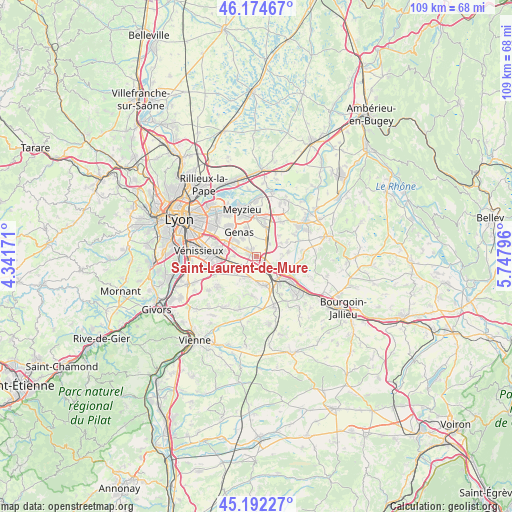
Saint-Laurent-de-Mure GPS coordinates[2]
45° 41' 8.268" North, 5° 2' 41.424" East
| Map corner | latitude | longitude |
|---|---|---|
| Upper-left | 46.17467°, | 4.34171° |
| Center: | 45.68563°, | 5.04484° |
| Lower-right: | 45.19227°, | 5.74796° |
| Map W x H: | 109.2×109.2 km | = 67.9×67.9mi |
| max Lat: | 51.07786° ⇑71.1% North |
| Saint-Laurent-de-Mure: | 45.68563° |
| min Lat: | ⇓28.9% South 41.3874° |
| min Long | Saint-Laurent-d | max Long |
| -5.08615° | 5.04484° | 9.52242° |
| W 78.1%⇐ | ⇒21.9% E |
Elevation
Elevation of Saint-Laurent-de-Mure is 241 m = 791 ft, and this is 47.3 m = 155 ft above average elevation for this country.
| Max E: |
2333 m = 7654 ft | 26.2% |
| Saint-Laurent-de-Mure | 241 m 791 ft | |
| Avg. | 193.7 m = 635 ft | |
Min E: |
-1 m = -3 ft | 73.8% |
See also: France elevation on elevation.city.
Geographical zone
Saint-Laurent-de-Mure is located in North temperate zone (between Tropic of Cancer and the Arctic Circle). Distance of this North polar circle is 2321.4 km =1442.5 mi to North.| Distance of | km | miles | from Saint-Laurent-de-Mure |
|---|---|---|---|
| North Pole | 4927.3 | 3061.7 | to North |
| Arctic Circle | 2321.4 | 1442.5 | to North |
| Tropic Cancer | 2473.8 | 1537.1 | to South |
| Equator | 5079.8 | 3156.4 | to South |


Nearby cities:
15 places around Saint-Laurent-de-Mure: (largest is in red/bold)
• Chassieu
8.8 km =5.5 mi,  319°
319°
• Genas
6.1 km =3.8 mi,  326°
326°
• Grenay
3.7 km =2.3 mi,  131°
131°
• Heyrieux
6.1 km =3.8 mi,  166°
166°
• Janneyrias
9.1 km =5.7 mi,  35°
35°
• Meyzieu
9.6 km =6 mi,  340°
340°
• Mions
7.6 km =4.7 mi,  250°
250°
• Pusignan
8 km =5 mi,  12°
12°
• Saint-Bonnet-de-Mure
1.3 km =0.8 mi,  293°
293°
• Saint-Pierre-de-Chandieu
5 km =3.1 mi,  208°
208°
• Saint-Priest
7.9 km =4.9 mi,  278°
278°
• Saint-Quentin-Fallavier
7.1 km =4.4 mi, 131°
• Satolas-et-Bonce
6.7 km =4.2 mi,  82°
82°
• Toussieu
5.8 km =3.6 mi,  233°
233°
• Valencin
8.4 km =5.2 mi,  188°
188°
Sources, notices
• [Note1] Compared only with cities in France existing in our database
• [Src1] Map data: © OpenStreetMap contributors (CC-BY-SA)
• [Src2] Other city data from geonames.org with taken over terms of usage.
• [Src3] Geographical zone / Annual Mean Temperature by Robert A. Rohde @ Wikipedia
