Tourtour geodata
Tourtour (Provence-Alpes-Côte d'Azur) is a populated place; located in France in Europe/Paris (GMT+2) time zone. With population of 515 people, there are 14927 cities with bigger population in this country. Compared to other cities in France, 92% of cities are located further ↑North; 90.2% of cities are located further ←West and 95.4% of cities have lower elevation than Tourtour. Note1
Administrative division(s):
- Level 1: Provence-Alpes-Côte d'Azur
- Level 2: Var
- Level 3: Arrondissement de Brignoles
- Level 4: Tourtour


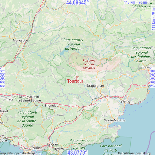
Tourtour GPS coordinates[2]
43° 35' 21.588" North, 6° 18' 8.748" East
| Map corner | latitude | longitude |
|---|---|---|
| Upper-left | 44.09645°, | 5.59931° |
| Center: | 43.58933°, | 6.30243° |
| Lower-right: | 43.0779°, | 7.00556° |
| Map W x H: | 113.3×113.3 km | = 70.4×70.4mi |
| max Lat: | 51.07786° ⇑92% North |
| Tourtour: | 43.58933° |
| min Lat: | ⇓8% South 41.3874° |
| min Long | Tourtour | max Long |
| -5.08615° | 6.30243° | 9.52242° |
| W 90.2%⇐ | ⇒9.8% E |
Elevation
Elevation of Tourtour is 605 m = 1985 ft, and this is 411.3 m = 1349 ft above average elevation for this country.
| Max E: |
2333 m = 7654 ft | 4.6% |
| Tourtour | 605 m 1985 ft | |
| Avg. | 193.7 m = 635 ft | |
Min E: |
-1 m = -3 ft | 95.4% |
See also: France elevation on elevation.city.
Geographical zone
Tourtour is located in North temperate zone (between Tropic of Cancer and the Arctic Circle). Distance of this Northern Tropic circle is 2240.8 km =1392.4 mi to South.| Distance of | km | miles | from Tourtour |
|---|---|---|---|
| North Pole | 5160.4 | 3206.5 | to North |
| Arctic Circle | 2554.5 | 1587.3 | to North |
| Tropic Cancer | 2240.8 | 1392.4 | to South |
| Equator | 4846.7 | 3011.6 | to South |


Nearby cities:
15 places around Tourtour: (largest is in red/bold)
• Ampus
6.7 km =4.2 mi,  72°
72°
• Aups
7.6 km =4.7 mi,  304°
304°
• Carcès
15.9 km =9.9 mi,  217°
217°
• Cotignac
14 km =8.7 mi,  241°
241°
• Draguignan
14.3 km =8.9 mi,  114°
114°
• Entrecasteaux
9.5 km =5.9 mi,  210°
210°
• Figanières
15.9 km =9.9 mi,  98°
98°
• Flayosc
9.8 km =6.1 mi,  129°
129°
• Le Thoronet
15.3 km =9.5 mi,  179°
179°
• Lorgues
11.7 km =7.3 mi,  155°
155°
• Montferrat
14.6 km =9.1 mi,  80°
80°
• Régusse
15.6 km =9.7 mi, 298°
• Salernes
6.2 km =3.9 mi, 242°
• Sillans-la-Cascade
10.2 km =6.3 mi,  256°
256°
• Villecroze
2.3 km =1.4 mi,  249°
249°
Sources, notices
• [Note1] Compared only with cities in France existing in our database
• [Src1] Map data: © OpenStreetMap contributors (CC-BY-SA)
• [Src2] Other city data from geonames.org with taken over terms of usage.
• [Src3] Geographical zone / Annual Mean Temperature by Robert A. Rohde @ Wikipedia
