Mazères geodata
Mazères (Nouvelle-Aquitaine) is a populated place; located in France in Europe/Paris (GMT+2) time zone. With population of 632 people, there are 12784 cities with bigger population in this country. Compared to other cities in France, 83.6% of cities are located further ↑North; 80.4% of cities are located further →East and 64.9% of cities have higher elevation than Mazères. Note1
Administrative division(s):
- Level 1: Nouvelle-Aquitaine
- Level 2: Gironde
- Level 3: Arrondissement de Langon
- Level 4: Mazères


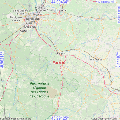
Mazères GPS coordinates[2]
44° 29' 41.82" North, 0° 15' 32.58" West
| Map corner | latitude | longitude |
|---|---|---|
| Upper-left | 44.99434°, | -0.96218° |
| Center: | 44.49495°, | -0.25905° |
| Lower-right: | 43.99125°, | 0.44407° |
| Map W x H: | 111.5×111.5 km | = 69.3×69.3mi |
| max Lat: | 51.07786° ⇑83.6% North |
| Mazères: | 44.49495° |
| min Lat: | ⇓16.4% South 41.3874° |
| min Long | Mazères | max Long |
| -5.08615° | -0.25905° | 9.52242° |
| W 19.6%⇐ | ⇒80.4% E |
Elevation
Elevation of Mazères is 90 m = 295 ft, and this is 103.7 m = 340 ft below average elevation for this country.
| Max E: |
2333 m = 7654 ft | 64.9% |
| Avg. | 193.7 m = 635 ft | |
| Mazères | 90 m = 295 ft | |
Min E: |
-1 m = -3 ft | 35.1% |
See also: France elevation on elevation.city.
Geographical zone
Mazères is located in North temperate zone (between Tropic of Cancer and the Arctic Circle). Distance of this Northern Tropic circle is 2341.5 km =1454.9 mi to South.| Distance of | km | miles | from Mazères |
|---|---|---|---|
| North Pole | 5059.7 | 3144 | to North |
| Arctic Circle | 2453.8 | 1524.7 | to North |
| Tropic Cancer | 2341.5 | 1454.9 | to South |
| Equator | 4947.4 | 3074.2 | to South |


Nearby cities:
15 places around Mazères: (largest is in red/bold)
• Auros
9.1 km =5.7 mi,  90°
90°
• Bazas
7.9 km =4.9 mi,  152°
152°
• Bommes
9.5 km =5.9 mi,  306°
306°
• Coimères
4 km =2.5 mi, 87°
• Langon
6.5 km =4 mi,  6°
6°
• Léogeats
8.7 km =5.4 mi,  282°
282°
• Noaillan
8.7 km =5.4 mi,  259°
259°
• Preignac
10.3 km =6.4 mi,  344°
344°
• Roaillan
1.9 km =1.2 mi, 281°
• Saint-Macaire
8.3 km =5.2 mi,  19°
19°
• Saint-Maixant
9.3 km =5.8 mi,  359°
359°
• Saint-Pierre-d’Aurillac
10.2 km =6.3 mi,  32°
32°
• Sauternes
7.8 km =4.8 mi,  302°
302°
• Toulenne
6.9 km =4.3 mi, 357°
• Villandraut
9.8 km =6.1 mi,  244°
244°
Sources, notices
• [Note1] Compared only with cities in France existing in our database
• [Src1] Map data: © OpenStreetMap contributors (CC-BY-SA)
• [Src2] Other city data from geonames.org with taken over terms of usage.
• [Src3] Geographical zone / Annual Mean Temperature by Robert A. Rohde @ Wikipedia
