Sauternes geodata
Sauternes (Nouvelle-Aquitaine) is a populated place; located in France in Europe/Paris (GMT+2) time zone. With population of 644 people, there are 12610 cities with bigger population in this country. Compared to other cities in France, 83.3% of cities are located further ↑North; 81.3% of cities are located further →East and 77.3% of cities have higher elevation than Sauternes. Note1
Administrative division(s):
- Level 1: Nouvelle-Aquitaine
- Level 2: Gironde
- Level 3: Arrondissement de Langon
- Level 4: Sauternes


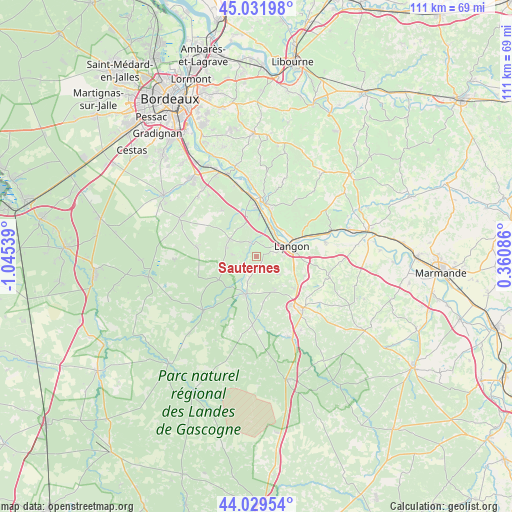
Sauternes GPS coordinates[2]
44° 31' 58.512" North, 0° 20' 32.136" West
| Map corner | latitude | longitude |
|---|---|---|
| Upper-left | 45.03198°, | -1.04539° |
| Center: | 44.53292°, | -0.34226° |
| Lower-right: | 44.02954°, | 0.36086° |
| Map W x H: | 111.5×111.5 km | = 69.3×69.3mi |
| max Lat: | 51.07786° ⇑83.3% North |
| Sauternes: | 44.53292° |
| min Lat: | ⇓16.7% South 41.3874° |
| min Long | Sauternes | max Long |
| -5.08615° | -0.34226° | 9.52242° |
| W 18.7%⇐ | ⇒81.3% E |
Elevation
Elevation of Sauternes is 61 m = 200 ft, and this is 132.7 m = 435 ft below average elevation for this country.
| Max E: |
2333 m = 7654 ft | 77.3% |
| Avg. | 193.7 m = 635 ft | |
| Sauternes | 61 m = 200 ft | |
Min E: |
-1 m = -3 ft | 22.7% |
See also: France elevation on elevation.city.
Geographical zone
Sauternes is located in North temperate zone (between Tropic of Cancer and the Arctic Circle). Distance of this Northern Tropic circle is 2345.7 km =1457.5 mi to South.| Distance of | km | miles | from Sauternes |
|---|---|---|---|
| North Pole | 5055.5 | 3141.3 | to North |
| Arctic Circle | 2449.6 | 1522.1 | to North |
| Tropic Cancer | 2345.7 | 1457.5 | to South |
| Equator | 4951.6 | 3076.8 | to South |


Nearby cities:
15 places around Sauternes: (largest is in red/bold)
• Barsac
8.6 km =5.3 mi,  14°
14°
• Bommes
1.8 km =1.1 mi,  324°
324°
• Budos
3.5 km =2.2 mi,  271°
271°
• Illats
7.5 km =4.7 mi,  341°
341°
• Landiras
6.9 km =4.3 mi,  303°
303°
• Langon
7.7 km =4.8 mi,  73°
73°
• Léogeats
3 km =1.9 mi,  219°
219°
• Mazères
7.8 km =4.8 mi,  122°
122°
• Noaillan
6.1 km =3.8 mi,  198°
198°
• Preignac
6.9 km =4.3 mi,  33°
33°
• Pujols-sur-Ciron
3.3 km =2.1 mi, 339°
• Roaillan
6.1 km =3.8 mi,  128°
128°
• Saint-Maixant
8.3 km =5.2 mi,  52°
52°
• Toulenne
6.8 km =4.2 mi, 67°
• Villandraut
8.7 km =5.4 mi, 195°
Sources, notices
• [Note1] Compared only with cities in France existing in our database
• [Src1] Map data: © OpenStreetMap contributors (CC-BY-SA)
• [Src2] Other city data from geonames.org with taken over terms of usage.
• [Src3] Geographical zone / Annual Mean Temperature by Robert A. Rohde @ Wikipedia
