Effiat geodata
Effiat (Auvergne-Rhône-Alpes) is a populated place; located in France in Europe/Paris (GMT+2) time zone. With population of 795 people, there are 10669 cities with bigger population in this country. Compared to other cities in France, 65.8% of cities are located further ↑North; 61.4% of cities are located further ←West and 84.4% of cities have lower elevation than Effiat. Note1
Administrative division(s):
- Level 1: Auvergne-Rhône-Alpes
- Level 2: Département du Puy-de-Dôme
- Level 3: Arrondissement de Riom
- Level 4: Effiat


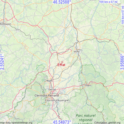
Effiat GPS coordinates[2]
46° 2' 23.856" North, 3° 15' 19.944" East
| Map corner | latitude | longitude |
|---|---|---|
| Upper-left | 46.52588°, | 2.55241° |
| Center: | 46.03996°, | 3.25554° |
| Lower-right: | 45.54973°, | 3.95866° |
| Map W x H: | 108.5×108.5 km | = 67.4×67.4mi |
| max Lat: | 51.07786° ⇑65.8% North |
| Effiat: | 46.03996° |
| min Lat: | ⇓34.2% South 41.3874° |
| min Long | Effiat | max Long |
| -5.08615° | 3.25554° | 9.52242° |
| W 61.4%⇐ | ⇒38.6% E |
Elevation
Elevation of Effiat is 340 m = 1115 ft, and this is 146.3 m = 480 ft above average elevation for this country.
| Max E: |
2333 m = 7654 ft | 15.6% |
| Effiat | 340 m 1115 ft | |
| Avg. | 193.7 m = 635 ft | |
Min E: |
-1 m = -3 ft | 84.4% |
See also: France elevation on elevation.city.
Geographical zone
Effiat is located in North temperate zone (between Tropic of Cancer and the Arctic Circle). Distance of this North polar circle is 2282 km =1418 mi to North.| Distance of | km | miles | from Effiat |
|---|---|---|---|
| North Pole | 4887.9 | 3037.2 | to North |
| Arctic Circle | 2282 | 1418 | to North |
| Tropic Cancer | 2513.2 | 1561.6 | to South |
| Equator | 5119.2 | 3180.9 | to South |


Nearby cities:
15 places around Effiat: (largest is in red/bold)
• Aigueperse
4.5 km =2.8 mi,  244°
244°
• Artonne
9.5 km =5.9 mi, 244°
• Biozat
4.3 km =2.7 mi,  17°
17°
• Brugheas
9.6 km =6 mi,  64°
64°
• Cellule
13.6 km =8.5 mi,  220°
220°
• Cognat-Lyonne
8.7 km =5.4 mi,  29°
29°
• Escurolles
11.5 km =7.1 mi,  3°
3°
• Espinasse-Vozelle
11 km =6.8 mi, 28°
• Gannat
8 km =5 mi,  326°
326°
• Martres-sur-Morge
11.8 km =7.3 mi,  193°
193°
• Pragoulin
10.8 km =6.7 mi,  81°
81°
• Randan
8.1 km =5 mi,  107°
107°
• Saint-Ignat
13.1 km =8.1 mi,  173°
173°
• Serbannes
10.3 km =6.4 mi,  50°
50°
• Thuret
7.9 km =4.9 mi,  178°
178°
Sources, notices
• [Note1] Compared only with cities in France existing in our database
• [Src1] Map data: © OpenStreetMap contributors (CC-BY-SA)
• [Src2] Other city data from geonames.org with taken over terms of usage.
• [Src3] Geographical zone / Annual Mean Temperature by Robert A. Rohde @ Wikipedia
