Thiers geodata
Thiers (Auvergne-Rhône-Alpes) is a seat of a third-order administrative division; located in France in Europe/Paris (GMT+2) time zone. With population of 13,739 people, there are 690 cities with bigger population in this country. Compared to other cities in France, 68.4% of cities are located further ↑North; 64.7% of cities are located further ←West and 89.9% of cities have lower elevation than Thiers. Note1
Administrative division(s):
- Level 1: Auvergne-Rhône-Alpes
- Level 2: Département du Puy-de-Dôme
- Level 3: Arrondissement de Thiers
- Level 4: Thiers


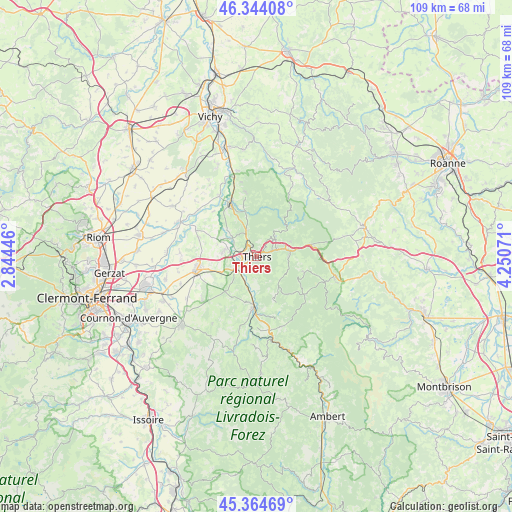
Thiers GPS coordinates[2]
45° 51' 23.544" North, 3° 32' 51.288" East
| Map corner | latitude | longitude |
|---|---|---|
| Upper-left | 46.34408°, | 2.84446° |
| Center: | 45.85654°, | 3.54758° |
| Lower-right: | 45.36469°, | 4.25071° |
| Map W x H: | 108.9×108.9 km | = 67.7×67.7mi |
| max Lat: | 51.07786° ⇑68.4% North |
| Thiers: | 45.85654° |
| min Lat: | ⇓31.6% South 41.3874° |
| min Long | Thiers | max Long |
| -5.08615° | 3.54758° | 9.52242° |
| W 64.7%⇐ | ⇒35.3% E |
Elevation
Elevation of Thiers is 424 m = 1391 ft, and this is 230.3 m = 756 ft above average elevation for this country.
| Max E: |
2333 m = 7654 ft | 10.1% |
| Thiers | 424 m 1391 ft | |
| Avg. | 193.7 m = 635 ft | |
Min E: |
-1 m = -3 ft | 89.9% |
See also: France elevation on elevation.city.
Geographical zone
Thiers is located in North temperate zone (between Tropic of Cancer and the Arctic Circle). Distance of this North polar circle is 2302.4 km =1430.6 mi to North.| Distance of | km | miles | from Thiers |
|---|---|---|---|
| North Pole | 4908.3 | 3049.9 | to North |
| Arctic Circle | 2302.4 | 1430.6 | to North |
| Tropic Cancer | 2492.9 | 1549 | to South |
| Equator | 5098.8 | 3168.2 | to South |


Nearby cities:
15 places around Thiers: (largest is in red/bold)
• Arconsat
13.3 km =8.3 mi,  74°
74°
• Celles-sur-Durolle
6.8 km =4.2 mi,  88°
88°
• Chabreloche
11.8 km =7.3 mi,  77°
77°
• Courpière
11.1 km =6.9 mi,  182°
182°
• Dorat
6.5 km =4 mi,  307°
307°
• Escoutoux
4.3 km =2.7 mi,  163°
163°
• La Monnerie-le-Montel
4.4 km =2.7 mi, 68°
• Orléat
9.8 km =6.1 mi,  272°
272°
• Palladuc
8.2 km =5.1 mi,  49°
49°
• Paslières
8.9 km =5.5 mi,  334°
334°
• Peschadoires
5.4 km =3.4 mi,  231°
231°
• Puy-Guillaume
12.9 km =8 mi, 333°
• Saint-Rémy-sur-Durolle
4.9 km =3 mi,  44°
44°
• Sermentizon
11.1 km =6.9 mi,  199°
199°
• Vollore-Ville
9 km =5.6 mi,  152°
152°
Sources, notices
• [Note1] Compared only with cities in France existing in our database
• [Src1] Map data: © OpenStreetMap contributors (CC-BY-SA)
• [Src2] Other city data from geonames.org with taken over terms of usage.
• [Src3] Geographical zone / Annual Mean Temperature by Robert A. Rohde @ Wikipedia
