Peschadoires geodata
Peschadoires (Auvergne-Rhône-Alpes) is a populated place; located in France in Europe/Paris (GMT+2) time zone. With population of 2,060 people, there are 4663 cities with bigger population in this country. Compared to other cities in France, 68.9% of cities are located further ↑North; 64.2% of cities are located further ←West and 80.8% of cities have lower elevation than Peschadoires. Note1
Administrative division(s):
- Level 1: Auvergne-Rhône-Alpes
- Level 2: Département du Puy-de-Dôme
- Level 3: Arrondissement de Thiers
- Level 4: Peschadoires


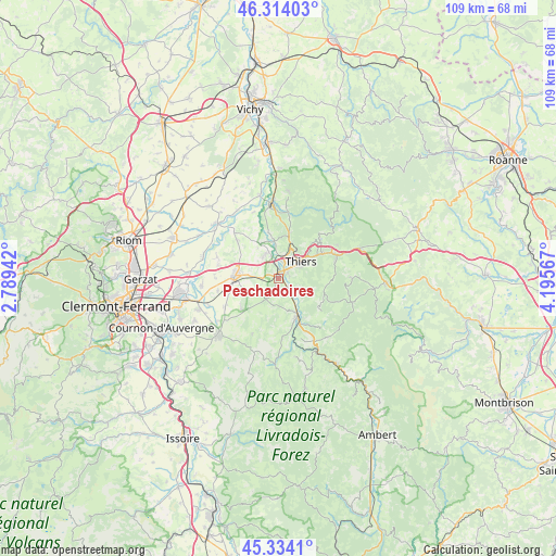
Peschadoires GPS coordinates[2]
45° 49' 34.392" North, 3° 29' 33.18" East
| Map corner | latitude | longitude |
|---|---|---|
| Upper-left | 46.31403°, | 2.78942° |
| Center: | 45.82622°, | 3.49255° |
| Lower-right: | 45.3341°, | 4.19567° |
| Map W x H: | 109×109 km | = 67.7×67.7mi |
| max Lat: | 51.07786° ⇑68.9% North |
| Peschadoires: | 45.82622° |
| min Lat: | ⇓31.1% South 41.3874° |
| min Long | Peschadoires | max Long |
| -5.08615° | 3.49255° | 9.52242° |
| W 64.2%⇐ | ⇒35.8% E |
Elevation
Elevation of Peschadoires is 299 m = 981 ft, and this is 105.3 m = 345 ft above average elevation for this country.
| Max E: |
2333 m = 7654 ft | 19.2% |
| Peschadoires | 299 m 981 ft | |
| Avg. | 193.7 m = 635 ft | |
Min E: |
-1 m = -3 ft | 80.8% |
See also: France elevation on elevation.city.
Geographical zone
Peschadoires is located in North temperate zone (between Tropic of Cancer and the Arctic Circle). Distance of this North polar circle is 2305.8 km =1432.8 mi to North.| Distance of | km | miles | from Peschadoires |
|---|---|---|---|
| North Pole | 4911.7 | 3052 | to North |
| Arctic Circle | 2305.8 | 1432.8 | to North |
| Tropic Cancer | 2489.5 | 1546.9 | to South |
| Equator | 5095.4 | 3166.1 | to South |


Nearby cities:
15 places around Peschadoires: (largest is in red/bold)
• Celles-sur-Durolle
11.6 km =7.2 mi,  72°
72°
• Courpière
8.6 km =5.3 mi,  153°
153°
• Culhat
12.7 km =7.9 mi,  288°
288°
• Dorat
7.4 km =4.6 mi,  353°
353°
• Escoutoux
5.5 km =3.4 mi,  97°
97°
• La Monnerie-le-Montel
9.8 km =6.1 mi,  59°
59°
• Lezoux
8.8 km =5.5 mi,  270°
270°
• Moissat Haut
12.1 km =7.5 mi,  242°
242°
• Orléat
6.7 km =4.2 mi,  304°
304°
• Paslières
11.4 km =7.1 mi,  1°
1°
• Ravel
9.2 km =5.7 mi,  234°
234°
• Saint-Rémy-sur-Durolle
10.4 km =6.5 mi,  48°
48°
• Sermentizon
7.2 km =4.5 mi,  175°
175°
• Thiers
5.4 km =3.4 mi, 51°
• Vollore-Ville
9.5 km =5.9 mi,  118°
118°
Sources, notices
• [Note1] Compared only with cities in France existing in our database
• [Src1] Map data: © OpenStreetMap contributors (CC-BY-SA)
• [Src2] Other city data from geonames.org with taken over terms of usage.
• [Src3] Geographical zone / Annual Mean Temperature by Robert A. Rohde @ Wikipedia
