Palladuc geodata
Palladuc (Auvergne-Rhône-Alpes) is a populated place; located in France in Europe/Paris (GMT+2) time zone. With population of 522 people, there are 14782 cities with bigger population in this country. Compared to other cities in France, 67.5% of cities are located further ↑North; 65.2% of cities are located further ←West and 97.2% of cities have lower elevation than Palladuc. Note1
Administrative division(s):
- Level 1: Auvergne-Rhône-Alpes
- Level 2: Département du Puy-de-Dôme
- Level 3: Arrondissement de Thiers
- Level 4: Palladuc


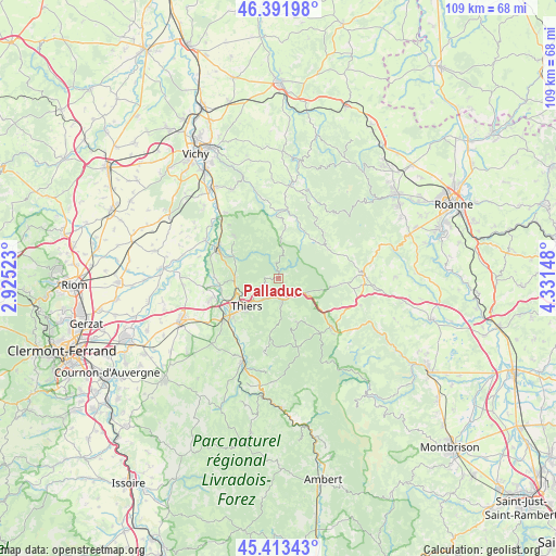
Palladuc GPS coordinates[2]
45° 54' 17.496" North, 3° 37' 42.06" East
| Map corner | latitude | longitude |
|---|---|---|
| Upper-left | 46.39198°, | 2.92523° |
| Center: | 45.90486°, | 3.62835° |
| Lower-right: | 45.41343°, | 4.33148° |
| Map W x H: | 108.8×108.8 km | = 67.6×67.6mi |
| max Lat: | 51.07786° ⇑67.5% North |
| Palladuc: | 45.90486° |
| min Lat: | ⇓32.5% South 41.3874° |
| min Long | Palladuc | max Long |
| -5.08615° | 3.62835° | 9.52242° |
| W 65.2%⇐ | ⇒34.8% E |
Elevation
Elevation of Palladuc is 739 m = 2425 ft, and this is 545.3 m = 1789 ft above average elevation for this country.
| Max E: |
2333 m = 7654 ft | 2.8% |
| Palladuc | 739 m 2425 ft | |
| Avg. | 193.7 m = 635 ft | |
Min E: |
-1 m = -3 ft | 97.2% |
See also: France elevation on elevation.city.
Geographical zone
Palladuc is located in North temperate zone (between Tropic of Cancer and the Arctic Circle). Distance of this North polar circle is 2297 km =1427.3 mi to North.| Distance of | km | miles | from Palladuc |
|---|---|---|---|
| North Pole | 4902.9 | 3046.5 | to North |
| Arctic Circle | 2297 | 1427.3 | to North |
| Tropic Cancer | 2498.2 | 1552.3 | to South |
| Equator | 5104.1 | 3171.5 | to South |


Nearby cities:
15 places around Palladuc: (largest is in red/bold)
• Arconsat
6.8 km =4.2 mi,  105°
105°
• Celles-sur-Durolle
5.2 km =3.2 mi,  173°
173°
• Chabreloche
6 km =3.7 mi,  118°
118°
• Châteldon
11.6 km =7.2 mi,  313°
313°
• Dorat
11.5 km =7.1 mi,  263°
263°
• Escoutoux
10.8 km =6.7 mi,  207°
207°
• Ferrières-sur-Sichon
13.5 km =8.4 mi,  6°
6°
• La Monnerie-le-Montel
4.3 km =2.7 mi, 209°
• Paslières
10.5 km =6.5 mi,  284°
284°
• Peschadoires
13.7 km =8.5 mi,  230°
230°
• Puy-Guillaume
13.4 km =8.3 mi,  297°
297°
• Ris
14.1 km =8.8 mi,  317°
317°
• Saint-Rémy-sur-Durolle
3.3 km =2.1 mi,  236°
236°
• Thiers
8.2 km =5.1 mi, 229°
• Vollore-Ville
13.5 km =8.4 mi,  189°
189°
Sources, notices
• [Note1] Compared only with cities in France existing in our database
• [Src1] Map data: © OpenStreetMap contributors (CC-BY-SA)
• [Src2] Other city data from geonames.org with taken over terms of usage.
• [Src3] Geographical zone / Annual Mean Temperature by Robert A. Rohde @ Wikipedia
