Thiberville geodata
Thiberville (Normandy) is a populated place; located in France in Europe/Paris (GMT+2) time zone. With population of 1,652 people, there are 5659 cities with bigger population in this country. Compared to other cities in France, 83.1% of cities are located further ↓South; 73.9% of cities are located further →East and 60.3% of cities have lower elevation than Thiberville. Note1
Administrative division(s):
- Level 1: Normandy
- Level 2: Département de l'Eure
- Level 3: Arrondissement de Bernay
- Level 4: Thiberville


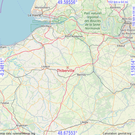
Thiberville GPS coordinates[2]
49° 8' 15.648" North, 0° 27' 18.072" East
| Map corner | latitude | longitude |
|---|---|---|
| Upper-left | 49.59556°, | -0.24811° |
| Center: | 49.13768°, | 0.45502° |
| Lower-right: | 48.67553°, | 1.15814° |
| Map W x H: | 102.3×102.3 km | = 63.6×63.6mi |
| max Lat: | 51.07786° ⇑16.9% North |
| Thiberville: | 49.13768° |
| min Lat: | ⇓83.1% South 41.3874° |
| min Long | Thiberville | max Long |
| -5.08615° | 0.45502° | 9.52242° |
| W 26.1%⇐ | ⇒73.9% E |
Elevation
Elevation of Thiberville is 171 m = 561 ft, and this is 22.7 m = 74 ft below average elevation for this country.
| Max E: |
2333 m = 7654 ft | 39.7% |
| Avg. | 193.7 m = 635 ft | |
| Thiberville | 171 m = 561 ft | |
Min E: |
-1 m = -3 ft | 60.3% |
See also: France elevation on elevation.city.
Geographical zone
Thiberville is located in North temperate zone (between Tropic of Cancer and the Arctic Circle). Distance of this North polar circle is 1937.6 km =1204 mi to North.| Distance of | km | miles | from Thiberville |
|---|---|---|---|
| North Pole | 4543.5 | 2823.2 | to North |
| Arctic Circle | 1937.6 | 1204 | to North |
| Tropic Cancer | 2857.7 | 1775.7 | to South |
| Equator | 5463.6 | 3394.9 | to South |


Nearby cities:
15 places around Thiberville: (largest is in red/bold)
• Bernay
11.8 km =7.3 mi,  117°
117°
• Caorches-Saint-Nicolas
9.2 km =5.7 mi,  131°
131°
• Courbépine
7.9 km =4.9 mi,  99°
99°
• Courtonne-la-Meurdrac
9.9 km =6.2 mi,  262°
262°
• Courtonne-les-Deux-Églises
8.8 km =5.5 mi,  226°
226°
• Drucourt
2.6 km =1.6 mi,  162°
162°
• La Chapelle-Yvon
11.8 km =7.3 mi, 225°
• Le Pin
12 km =7.5 mi,  313°
313°
• Lieurey
10.8 km =6.7 mi,  17°
17°
• Marolles
6 km =3.7 mi,  271°
271°
• Menneval
12.5 km =7.8 mi,  109°
109°
• Moyaux
9.6 km =6 mi, 311°
• Plasnes
12.2 km =7.6 mi,  90°
90°
• Saint-Germain-la-Campagne
10.6 km =6.6 mi,  199°
199°
• Saint-Martin-de-Mailloc
12.3 km =7.6 mi,  245°
245°
Sources, notices
• [Note1] Compared only with cities in France existing in our database
• [Src1] Map data: © OpenStreetMap contributors (CC-BY-SA)
• [Src2] Other city data from geonames.org with taken over terms of usage.
• [Src3] Geographical zone / Annual Mean Temperature by Robert A. Rohde @ Wikipedia
