Menneval geodata
Menneval (Normandy) is a populated place; located in France in Europe/Paris (GMT+2) time zone. With population of 1,432 people, there are 6472 cities with bigger population in this country. Compared to other cities in France, 82.1% of cities are located further ↓South; 72.2% of cities are located further →East and 55.6% of cities have lower elevation than Menneval. Note1
Administrative division(s):
- Level 1: Normandy
- Level 2: Département de l'Eure
- Level 3: Arrondissement de Bernay
- Level 4: Menneval


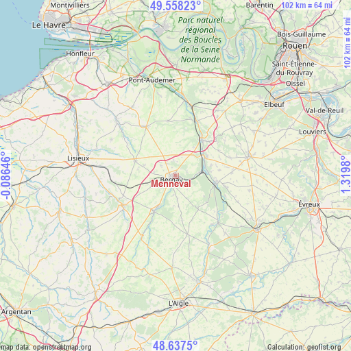
Menneval GPS coordinates[2]
49° 6' 0" North, 0° 37' 0.012" East
| Map corner | latitude | longitude |
|---|---|---|
| Upper-left | 49.55823°, | -0.08646° |
| Center: | 49.1°, | 0.61667° |
| Lower-right: | 48.6375°, | 1.3198° |
| Map W x H: | 102.4×102.4 km | = 63.6×63.6mi |
| max Lat: | 51.07786° ⇑17.9% North |
| Menneval: | 49.1° |
| min Lat: | ⇓82.1% South 41.3874° |
| min Long | Menneval | max Long |
| -5.08615° | 0.61667° | 9.52242° |
| W 27.8%⇐ | ⇒72.2% E |
Elevation
Elevation of Menneval is 152 m = 499 ft, and this is 41.7 m = 137 ft below average elevation for this country.
| Max E: |
2333 m = 7654 ft | 44.4% |
| Avg. | 193.7 m = 635 ft | |
| Menneval | 152 m = 499 ft | |
Min E: |
-1 m = -3 ft | 55.6% |
See also: France elevation on elevation.city.
Geographical zone
Menneval is located in North temperate zone (between Tropic of Cancer and the Arctic Circle). Distance of this North polar circle is 1941.8 km =1206.6 mi to North.| Distance of | km | miles | from Menneval |
|---|---|---|---|
| North Pole | 4547.7 | 2825.8 | to North |
| Arctic Circle | 1941.8 | 1206.6 | to North |
| Tropic Cancer | 2853.5 | 1773.1 | to South |
| Equator | 5459.4 | 3392.3 | to South |


Nearby cities:
15 places around Menneval: (largest is in red/bold)
• Beaumesnil
11.8 km =7.3 mi,  146°
146°
• Beaumont-le-Roger
12.2 km =7.6 mi,  101°
101°
• Beaumontel
10.8 km =6.7 mi, 100°
• Bernay
1.8 km =1.1 mi,  226°
226°
• Brionne
12.8 km =8 mi,  33°
33°
• Broglie
11.9 km =7.4 mi,  212°
212°
• Caorches-Saint-Nicolas
5.2 km =3.2 mi,  249°
249°
• Courbépine
5 km =3.1 mi,  306°
306°
• Drucourt
11.1 km =6.9 mi,  278°
278°
• Goupillières
11 km =6.8 mi,  73°
73°
• Nassandres
9.2 km =5.7 mi, 71°
• Plasnes
4.1 km =2.5 mi,  6°
6°
• Saint-Aubin-le-Vertueux
5.5 km =3.4 mi,  187°
187°
• Serquigny
6.9 km =4.3 mi,  81°
81°
• Thiberville
12.5 km =7.8 mi,  289°
289°
Sources, notices
• [Note1] Compared only with cities in France existing in our database
• [Src1] Map data: © OpenStreetMap contributors (CC-BY-SA)
• [Src2] Other city data from geonames.org with taken over terms of usage.
• [Src3] Geographical zone / Annual Mean Temperature by Robert A. Rohde @ Wikipedia
