Teillay geodata
Teillay (Brittany) is a populated place; located in France in Europe/Paris (GMT+2) time zone. With population of 852 people, there are 10061 cities with bigger population in this country. Compared to other cities in France, 55.9% of cities are located further ↓South; 92.6% of cities are located further →East and 70.5% of cities have higher elevation than Teillay. Note1
Administrative division(s):
- Level 1: Brittany
- Level 2: Département d'Ille-et-Vilaine
- Level 3: Arrondissement de Redon
- Level 4: Teillay


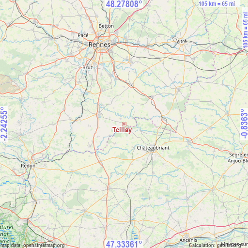
Teillay GPS coordinates[2]
47° 48' 28.764" North, 1° 32' 21.912" West
| Map corner | latitude | longitude |
|---|---|---|
| Upper-left | 48.27808°, | -2.24255° |
| Center: | 47.80799°, | -1.53942° |
| Lower-right: | 47.33361°, | -0.8363° |
| Map W x H: | 105×105 km | = 65.2×65.2mi |
| max Lat: | 51.07786° ⇑44.1% North |
| Teillay: | 47.80799° |
| min Lat: | ⇓55.9% South 41.3874° |
| min Long | Teillay | max Long |
| -5.08615° | -1.53942° | 9.52242° |
| W 7.4%⇐ | ⇒92.6% E |
Elevation
Elevation of Teillay is 77 m = 253 ft, and this is 116.7 m = 383 ft below average elevation for this country.
| Max E: |
2333 m = 7654 ft | 70.5% |
| Avg. | 193.7 m = 635 ft | |
| Teillay | 77 m = 253 ft | |
Min E: |
-1 m = -3 ft | 29.5% |
See also: France elevation on elevation.city.
Geographical zone
Teillay is located in North temperate zone (between Tropic of Cancer and the Arctic Circle). Distance of this North polar circle is 2085.4 km =1295.8 mi to North.| Distance of | km | miles | from Teillay |
|---|---|---|---|
| North Pole | 4691.3 | 2915 | to North |
| Arctic Circle | 2085.4 | 1295.8 | to North |
| Tropic Cancer | 2709.8 | 1683.8 | to South |
| Equator | 5315.8 | 3303.1 | to South |


Nearby cities:
15 places around Teillay: (largest is in red/bold)
• Bain-de-Bretagne
11.6 km =7.2 mi,  290°
290°
• Coësmes
11.1 km =6.9 mi,  41°
41°
• Ercé-en-Lamée
2.9 km =1.8 mi,  330°
330°
• Fercé
9.3 km =5.8 mi,  98°
98°
• La Dominelais
12.2 km =7.6 mi,  245°
245°
• Lalleu
5.7 km =3.5 mi,  21°
21°
• Le Sel-de-Bretagne
11.7 km =7.3 mi, 330°
• Pancé
12.2 km =7.6 mi,  312°
312°
• Rougé
7.4 km =4.6 mi,  111°
111°
• Ruffigné
6.6 km =4.1 mi,  149°
149°
• Saint-Aubin-des-Châteaux
10.4 km =6.5 mi,  158°
158°
• Saulnières
12.4 km =7.7 mi,  343°
343°
• Sion-les-Mines
9 km =5.6 mi,  205°
205°
• Thourie
6.8 km =4.2 mi, 40°
• Tresbœuf
8.4 km =5.2 mi,  354°
354°
Sources, notices
• [Note1] Compared only with cities in France existing in our database
• [Src1] Map data: © OpenStreetMap contributors (CC-BY-SA)
• [Src2] Other city data from geonames.org with taken over terms of usage.
• [Src3] Geographical zone / Annual Mean Temperature by Robert A. Rohde @ Wikipedia
