Sion-les-Mines geodata
Sion-les-Mines (Pays de la Loire) is a populated place; located in France in Europe/Paris (GMT+2) time zone. With population of 1,478 people, there are 6259 cities with bigger population in this country. Compared to other cities in France, 54.8% of cities are located further ↓South; 92.9% of cities are located further →East and 74.6% of cities have higher elevation than Sion-les-Mines. Note1
Administrative division(s):
- Level 1: Pays de la Loire
- Level 2: Loire-Atlantique
- Level 3: Arrondissement of Châteaubriant-Ancenis
- Level 4: Sion-les-Mines


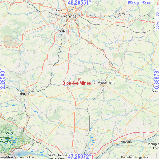
Sion-les-Mines GPS coordinates[2]
47° 44' 5.136" North, 1° 35' 30.84" West
| Map corner | latitude | longitude |
|---|---|---|
| Upper-left | 48.20551°, | -2.29503° |
| Center: | 47.73476°, | -1.5919° |
| Lower-right: | 47.25972°, | -0.88878° |
| Map W x H: | 105.2×105.2 km | = 65.4×65.4mi |
| max Lat: | 51.07786° ⇑45.2% North |
| Sion-les-Mines: | 47.73476° |
| min Lat: | ⇓54.8% South 41.3874° |
| min Long | Sion-les-Mines | max Long |
| -5.08615° | -1.5919° | 9.52242° |
| W 7.1%⇐ | ⇒92.9% E |
Elevation
Elevation of Sion-les-Mines is 68 m = 223 ft, and this is 125.7 m = 412 ft below average elevation for this country.
| Max E: |
2333 m = 7654 ft | 74.6% |
| Avg. | 193.7 m = 635 ft | |
| Sion-les-Mines | 68 m = 223 ft | |
Min E: |
-1 m = -3 ft | 25.4% |
See also: France elevation on elevation.city.
Geographical zone
Sion-les-Mines is located in North temperate zone (between Tropic of Cancer and the Arctic Circle). Distance of this North polar circle is 2093.6 km =1300.9 mi to North.| Distance of | km | miles | from Sion-les-Mines |
|---|---|---|---|
| North Pole | 4699.5 | 2920.1 | to North |
| Arctic Circle | 2093.6 | 1300.9 | to North |
| Tropic Cancer | 2701.7 | 1678.8 | to South |
| Equator | 5307.6 | 3298 | to South |


Nearby cities:
15 places around Sion-les-Mines: (largest is in red/bold)
• Derval
9.5 km =5.9 mi,  217°
217°
• Ercé-en-Lamée
10.9 km =6.8 mi,  13°
13°
• Grand-Fougeray
10.6 km =6.6 mi,  263°
263°
• Jans
12.8 km =8 mi,  187°
187°
• La Dominelais
7.8 km =4.8 mi,  293°
293°
• La Noë-Blanche
13.6 km =8.5 mi,  304°
304°
• Louisfert
13.6 km =8.5 mi,  119°
119°
• Lusanger
5.9 km =3.7 mi,  177°
177°
• Pierric
12 km =7.5 mi,  243°
243°
• Rougé
12.1 km =7.5 mi,  63°
63°
• Ruffigné
7.7 km =4.8 mi,  71°
71°
• Saint-Aubin-des-Châteaux
7.9 km =4.9 mi,  101°
101°
• Saint-Vincent-des-Landes
11.3 km =7 mi,  140°
140°
• Teillay
9 km =5.6 mi,  25°
25°
• Treffieux
13.4 km =8.3 mi,  162°
162°
Sources, notices
• [Note1] Compared only with cities in France existing in our database
• [Src1] Map data: © OpenStreetMap contributors (CC-BY-SA)
• [Src2] Other city data from geonames.org with taken over terms of usage.
• [Src3] Geographical zone / Annual Mean Temperature by Robert A. Rohde @ Wikipedia
