Sully geodata
Sully (Bourgogne-Franche-Comté) is a populated place; located in France in Europe/Paris (GMT+2) time zone. With population of 562 people, there are 13969 cities with bigger population in this country. Compared to other cities in France, 55.2% of cities are located further ↑North; 71.9% of cities are located further ←West and 82.5% of cities have lower elevation than Sully. Note1
Administrative division(s):
- Level 1: Bourgogne-Franche-Comté
- Level 2: Département de Saône-et-Loire
- Level 3: Autun
- Level 4: Sully


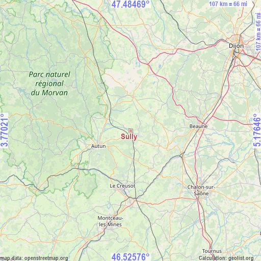
Sully GPS coordinates[2]
47° 0' 26.568" North, 4° 28' 23.988" East
| Map corner | latitude | longitude |
|---|---|---|
| Upper-left | 47.48469°, | 3.77021° |
| Center: | 47.00738°, | 4.47333° |
| Lower-right: | 46.52576°, | 5.17646° |
| Map W x H: | 106.6×106.6 km | = 66.2×66.2mi |
| max Lat: | 51.07786° ⇑55.2% North |
| Sully: | 47.00738° |
| min Lat: | ⇓44.8% South 41.3874° |
| min Long | Sully | max Long |
| -5.08615° | 4.47333° | 9.52242° |
| W 71.9%⇐ | ⇒28.1% E |
Elevation
Elevation of Sully is 316 m = 1037 ft, and this is 122.3 m = 401 ft above average elevation for this country.
| Max E: |
2333 m = 7654 ft | 17.5% |
| Sully | 316 m 1037 ft | |
| Avg. | 193.7 m = 635 ft | |
Min E: |
-1 m = -3 ft | 82.5% |
See also: France elevation on elevation.city.
Geographical zone
Sully is located in North temperate zone (between Tropic of Cancer and the Arctic Circle). Distance of this North polar circle is 2174.4 km =1351.1 mi to North.| Distance of | km | miles | from Sully |
|---|---|---|---|
| North Pole | 4780.3 | 2970.3 | to North |
| Arctic Circle | 2174.4 | 1351.1 | to North |
| Tropic Cancer | 2620.8 | 1628.5 | to South |
| Equator | 5226.7 | 3247.7 | to South |


Nearby cities:
15 places around Sully: (largest is in red/bold)
• Antully
12.5 km =7.8 mi,  202°
202°
• Arnay-le-Duc
13.9 km =8.6 mi,  3°
3°
• Autun
14.7 km =9.1 mi,  244°
244°
• Auxy
8.3 km =5.2 mi,  219°
219°
• Couches
17.2 km =10.7 mi,  155°
155°
• Curgy
7.1 km =4.4 mi,  251°
251°
• Dracy-Saint-Loup
9.9 km =6.2 mi,  275°
275°
• Igornay
8.4 km =5.2 mi,  300°
300°
• Lacanche
9.9 km =6.2 mi,  40°
40°
• Nolay
13.7 km =8.5 mi,  116°
116°
• Saint-Forgeot
13.1 km =8.1 mi,  268°
268°
• Saint-Léger-du-Bois
2.2 km =1.4 mi,  290°
290°
• Saint-Sernin-du-Plain
16.8 km =10.4 mi,  139°
139°
• Tavernay
18.1 km =11.2 mi, 272°
• Épinac
4.2 km =2.6 mi,  129°
129°
Sources, notices
• [Note1] Compared only with cities in France existing in our database
• [Src1] Map data: © OpenStreetMap contributors (CC-BY-SA)
• [Src2] Other city data from geonames.org with taken over terms of usage.
• [Src3] Geographical zone / Annual Mean Temperature by Robert A. Rohde @ Wikipedia
