Igornay geodata
Igornay (Bourgogne-Franche-Comté) is a populated place; located in France in Europe/Paris (GMT+2) time zone. With population of 504 people, there are 15167 cities with bigger population in this country. Compared to other cities in France, 54.8% of cities are located further ↑North; 71.2% of cities are located further ←West and 81.7% of cities have lower elevation than Igornay. Note1
Administrative division(s):
- Level 1: Bourgogne-Franche-Comté
- Level 2: Département de Saône-et-Loire
- Level 3: Autun
- Level 4: Igornay


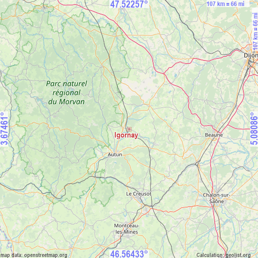
Igornay GPS coordinates[2]
47° 2' 44.16" North, 4° 22' 39.864" East
| Map corner | latitude | longitude |
|---|---|---|
| Upper-left | 47.52257°, | 3.67461° |
| Center: | 47.0456°, | 4.37774° |
| Lower-right: | 46.56433°, | 5.08086° |
| Map W x H: | 106.5×106.5 km | = 66.2×66.2mi |
| max Lat: | 51.07786° ⇑54.8% North |
| Igornay: | 47.0456° |
| min Lat: | ⇓45.2% South 41.3874° |
| min Long | Igornay | max Long |
| -5.08615° | 4.37774° | 9.52242° |
| W 71.2%⇐ | ⇒28.8% E |
Elevation
Elevation of Igornay is 307 m = 1007 ft, and this is 113.3 m = 372 ft above average elevation for this country.
| Max E: |
2333 m = 7654 ft | 18.3% |
| Igornay | 307 m 1007 ft | |
| Avg. | 193.7 m = 635 ft | |
Min E: |
-1 m = -3 ft | 81.7% |
See also: France elevation on elevation.city.
Geographical zone
Igornay is located in North temperate zone (between Tropic of Cancer and the Arctic Circle). Distance of this North polar circle is 2170.2 km =1348.5 mi to North.| Distance of | km | miles | from Igornay |
|---|---|---|---|
| North Pole | 4776.1 | 2967.7 | to North |
| Arctic Circle | 2170.2 | 1348.5 | to North |
| Tropic Cancer | 2625.1 | 1631.2 | to South |
| Equator | 5231 | 3250.4 | to South |


Nearby cities:
15 places around Igornay: (largest is in red/bold)
• Antully
16 km =9.9 mi,  171°
171°
• Arnay-le-Duc
12.6 km =7.8 mi,  40°
40°
• Autun
12.1 km =7.5 mi,  209°
209°
• Auxy
10.9 km =6.8 mi, 169°
• Broye
20.4 km =12.7 mi,  198°
198°
• Curgy
6.5 km =4 mi,  175°
175°
• Dracy-Saint-Loup
4.2 km =2.6 mi,  218°
218°
• La Grande-Verrière
20.1 km =12.5 mi,  243°
243°
• Lacanche
14.1 km =8.8 mi,  76°
76°
• Liernais
19.3 km =12 mi,  337°
337°
• Saint-Forgeot
7.5 km =4.7 mi,  231°
231°
• Saint-Léger-du-Bois
6.3 km =3.9 mi,  123°
123°
• Sully
8.4 km =5.2 mi, 120°
• Tavernay
11.4 km =7.1 mi,  252°
252°
• Épinac
12.6 km =7.8 mi, 123°
Sources, notices
• [Note1] Compared only with cities in France existing in our database
• [Src1] Map data: © OpenStreetMap contributors (CC-BY-SA)
• [Src2] Other city data from geonames.org with taken over terms of usage.
• [Src3] Geographical zone / Annual Mean Temperature by Robert A. Rohde @ Wikipedia
