Arnay-le-Duc geodata
Arnay-le-Duc (Bourgogne-Franche-Comté) is a populated place; located in France in Europe/Paris (GMT+2) time zone. With population of 1,986 people, there are 4819 cities with bigger population in this country. Compared to other cities in France, 53.9% of cities are located further ↑North; 72% of cities are located further ←West and 86.9% of cities have lower elevation than Arnay-le-Duc. Note1
Administrative division(s):
- Level 1: Bourgogne-Franche-Comté
- Level 2: Département de la Côte-d'Or
- Level 3: Arrondissement de Beaune
- Level 4: Arnay-le-Duc


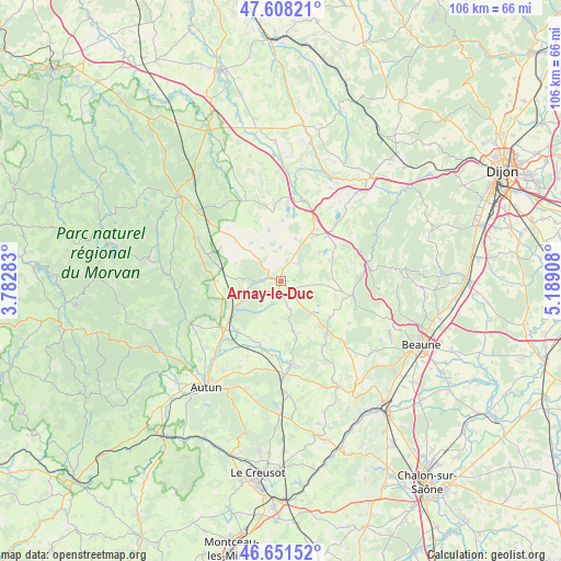
Arnay-le-Duc GPS coordinates[2]
47° 7' 55.272" North, 4° 29' 9.42" East
| Map corner | latitude | longitude |
|---|---|---|
| Upper-left | 47.60821°, | 3.78283° |
| Center: | 47.13202°, | 4.48595° |
| Lower-right: | 46.65152°, | 5.18908° |
| Map W x H: | 106.4×106.4 km | = 66.1×66.1mi |
| max Lat: | 51.07786° ⇑53.9% North |
| Arnay-le-Duc: | 47.13202° |
| min Lat: | ⇓46.1% South 41.3874° |
| min Long | Arnay-le-Duc | max Long |
| -5.08615° | 4.48595° | 9.52242° |
| W 72%⇐ | ⇒28% E |
Elevation
Elevation of Arnay-le-Duc is 372 m = 1220 ft, and this is 178.3 m = 585 ft above average elevation for this country.
| Max E: |
2333 m = 7654 ft | 13.1% |
| Arnay-le-Duc | 372 m 1220 ft | |
| Avg. | 193.7 m = 635 ft | |
Min E: |
-1 m = -3 ft | 86.9% |
See also: France elevation on elevation.city.
Geographical zone
Arnay-le-Duc is located in North temperate zone (between Tropic of Cancer and the Arctic Circle). Distance of this North polar circle is 2160.6 km =1342.5 mi to North.| Distance of | km | miles | from Arnay-le-Duc |
|---|---|---|---|
| North Pole | 4766.5 | 2961.8 | to North |
| Arctic Circle | 2160.6 | 1342.5 | to North |
| Tropic Cancer | 2634.7 | 1637.1 | to South |
| Equator | 5240.6 | 3256.4 | to South |


Nearby cities:
15 places around Arnay-le-Duc: (largest is in red/bold)
• Alligny-en-Morvan
24.5 km =15.2 mi,  287°
287°
• Auxy
21.2 km =13.2 mi,  196°
196°
• Bligny-sur-Ouche
14.2 km =8.8 mi,  101°
101°
• Curgy
17.8 km =11.1 mi,  205°
205°
• Dracy-Saint-Loup
16.8 km =10.4 mi,  220°
220°
• Igornay
12.6 km =7.8 mi, 220°
• Lacanche
8.4 km =5.2 mi,  138°
138°
• Liernais
17.5 km =10.9 mi,  298°
298°
• Nolay
22.9 km =14.2 mi,  150°
150°
• Pouilly-en-Auxois
15.4 km =9.6 mi,  20°
20°
• Saint-Forgeot
20 km =12.4 mi, 224°
• Saint-Léger-du-Bois
13.4 km =8.3 mi,  192°
192°
• Sully
13.9 km =8.6 mi,  183°
183°
• Tavernay
23.1 km =14.4 mi,  235°
235°
• Épinac
16.7 km =10.4 mi,  171°
171°
Sources, notices
• [Note1] Compared only with cities in France existing in our database
• [Src1] Map data: © OpenStreetMap contributors (CC-BY-SA)
• [Src2] Other city data from geonames.org with taken over terms of usage.
• [Src3] Geographical zone / Annual Mean Temperature by Robert A. Rohde @ Wikipedia
