Villandraut geodata
Villandraut (Nouvelle-Aquitaine) is a populated place; located in France in Europe/Paris (GMT+2) time zone. With population of 877 people, there are 9840 cities with bigger population in this country. Compared to other cities in France, 83.9% of cities are located further ↑North; 81.7% of cities are located further →East and 88.6% of cities have higher elevation than Villandraut. Note1
Administrative division(s):
- Level 1: Nouvelle-Aquitaine
- Level 2: Gironde
- Level 3: Arrondissement de Langon
- Level 4: Villandraut


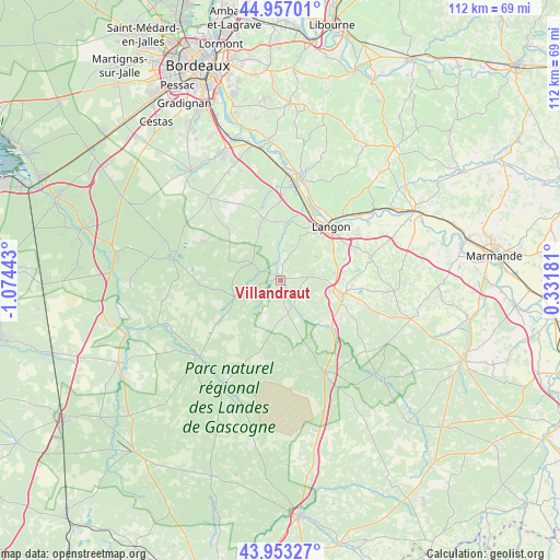
Villandraut GPS coordinates[2]
44° 27' 26.28" North, 0° 22' 16.716" West
| Map corner | latitude | longitude |
|---|---|---|
| Upper-left | 44.95701°, | -1.07443° |
| Center: | 44.4573°, | -0.37131° |
| Lower-right: | 43.95327°, | 0.33181° |
| Map W x H: | 111.6×111.6 km | = 69.3×69.3mi |
| max Lat: | 51.07786° ⇑83.9% North |
| Villandraut: | 44.4573° |
| min Lat: | ⇓16.1% South 41.3874° |
| min Long | Villandraut | max Long |
| -5.08615° | -0.37131° | 9.52242° |
| W 18.3%⇐ | ⇒81.7% E |
Elevation
Elevation of Villandraut is 33 m = 108 ft, and this is 160.7 m = 527 ft below average elevation for this country.
| Max E: |
2333 m = 7654 ft | 88.6% |
| Avg. | 193.7 m = 635 ft | |
| Villandraut | 33 m = 108 ft | |
Min E: |
-1 m = -3 ft | 11.4% |
See also: France elevation on elevation.city.
Geographical zone
Villandraut is located in North temperate zone (between Tropic of Cancer and the Arctic Circle). Distance of this Northern Tropic circle is 2337.3 km =1452.3 mi to South.| Distance of | km | miles | from Villandraut |
|---|---|---|---|
| North Pole | 5063.9 | 3146.6 | to North |
| Arctic Circle | 2458 | 1527.3 | to North |
| Tropic Cancer | 2337.3 | 1452.3 | to South |
| Equator | 4943.2 | 3071.6 | to South |


Nearby cities:
15 places around Villandraut: (largest is in red/bold)
• Bazas
12.9 km =8 mi,  102°
102°
• Bommes
10 km =6.2 mi,  7°
7°
• Budos
8.6 km =5.3 mi,  351°
351°
• Coimères
13.6 km =8.5 mi,  71°
71°
• Landiras
12.7 km =7.9 mi,  344°
344°
• Langon
14.4 km =8.9 mi,  42°
42°
• Léogeats
6.1 km =3.8 mi,  3°
3°
• Mazères
9.8 km =6.1 mi,  64°
64°
• Noaillan
2.6 km =1.6 mi, 8°
• Préchac
6.6 km =4.1 mi,  167°
167°
• Pujols-sur-Ciron
11.5 km =7.1 mi, 5°
• Roaillan
8.4 km =5.2 mi, 57°
• Saint-Symphorien
10 km =6.2 mi,  251°
251°
• Sauternes
8.7 km =5.4 mi,  15°
15°
• Toulenne
14 km =8.7 mi, 37°
Sources, notices
• [Note1] Compared only with cities in France existing in our database
• [Src1] Map data: © OpenStreetMap contributors (CC-BY-SA)
• [Src2] Other city data from geonames.org with taken over terms of usage.
• [Src3] Geographical zone / Annual Mean Temperature by Robert A. Rohde @ Wikipedia
