Arbouans geodata
Arbouans (Bourgogne-Franche-Comté) is a populated place; located in France in Europe/Paris (GMT+2) time zone. With population of 1,009 people, there are 8775 cities with bigger population in this country. Compared to other cities in France, 51.2% of cities are located further ↓South; 93.6% of cities are located further ←West and 85% of cities have lower elevation than Arbouans. Note1
Administrative division(s):
- Level 1: Bourgogne-Franche-Comté
- Level 2: Doubs
- Level 3: Arrondissement de Montbéliard
- Level 4: Arbouans


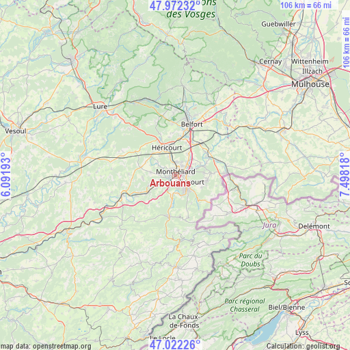
Arbouans GPS coordinates[2]
47° 29' 57.984" North, 6° 47' 42.18" East
| Map corner | latitude | longitude |
|---|---|---|
| Upper-left | 47.97232°, | 6.09193° |
| Center: | 47.49944°, | 6.79505° |
| Lower-right: | 47.02226°, | 7.49818° |
| Map W x H: | 105.6×105.6 km | = 65.6×65.6mi |
| max Lat: | 51.07786° ⇑48.8% North |
| Arbouans: | 47.49944° |
| min Lat: | ⇓51.2% South 41.3874° |
| min Long | Arbouans | max Long |
| -5.08615° | 6.79505° | 9.52242° |
| W 93.6%⇐ | ⇒6.4% E |
Elevation
Elevation of Arbouans is 347 m = 1138 ft, and this is 153.3 m = 503 ft above average elevation for this country.
| Max E: |
2333 m = 7654 ft | 15% |
| Arbouans | 347 m 1138 ft | |
| Avg. | 193.7 m = 635 ft | |
Min E: |
-1 m = -3 ft | 85% |
See also: France elevation on elevation.city.
Geographical zone
Arbouans is located in North temperate zone (between Tropic of Cancer and the Arctic Circle). Distance of this North polar circle is 2119.7 km =1317.1 mi to North.| Distance of | km | miles | from Arbouans |
|---|---|---|---|
| North Pole | 4725.6 | 2936.4 | to North |
| Arctic Circle | 2119.7 | 1317.1 | to North |
| Tropic Cancer | 2675.5 | 1662.5 | to South |
| Equator | 5281.4 | 3281.7 | to South |


Nearby cities:
15 places around Arbouans: (largest is in red/bold)
• Audincourt
4.7 km =2.9 mi,  112°
112°
• Bart
2.2 km =1.4 mi,  236°
236°
• Bavans
4.9 km =3 mi,  251°
251°
• Bethoncourt
4 km =2.5 mi,  10°
10°
• Courcelles-lès-Montbéliard
0.8 km =0.5 mi,  283°
283°
• Dung
3.2 km =2 mi, 276°
• Exincourt
2.8 km =1.7 mi,  100°
100°
• Grand-Charmont
3.8 km =2.4 mi,  37°
37°
• Montbéliard
1.2 km =0.7 mi, 11°
• Sainte-Suzanne
2.1 km =1.3 mi,  272°
272°
• Sochaux
2.6 km =1.6 mi,  68°
68°
• Taillecourt
4.5 km =2.8 mi, 96°
• Valentigney
4.8 km =3 mi,  145°
145°
• Vieux-Charmont
4 km =2.5 mi,  51°
51°
• Voujeaucourt
3.1 km =1.9 mi,  209°
209°
Sources, notices
• [Note1] Compared only with cities in France existing in our database
• [Src1] Map data: © OpenStreetMap contributors (CC-BY-SA)
• [Src2] Other city data from geonames.org with taken over terms of usage.
• [Src3] Geographical zone / Annual Mean Temperature by Robert A. Rohde @ Wikipedia
