Sainte-Suzanne geodata
Sainte-Suzanne (Bourgogne-Franche-Comté) is a populated place; located in France in Europe/Paris (GMT+2) time zone. With population of 1,414 people, there are 6543 cities with bigger population in this country. Compared to other cities in France, 51.2% of cities are located further ↓South; 93.5% of cities are located further ←West and 89% of cities have lower elevation than Sainte-Suzanne. Note1
Administrative division(s):
- Level 1: Bourgogne-Franche-Comté
- Level 2: Doubs
- Level 3: Arrondissement de Montbéliard
- Level 4: Sainte-Suzanne


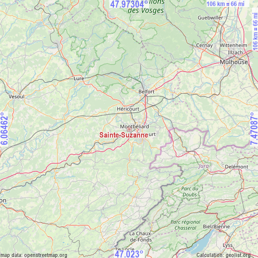
Sainte-Suzanne GPS coordinates[2]
47° 30' 0.612" North, 6° 46' 3.9" East
| Map corner | latitude | longitude |
|---|---|---|
| Upper-left | 47.97304°, | 6.06462° |
| Center: | 47.50017°, | 6.76775° |
| Lower-right: | 47.023°, | 7.47087° |
| Map W x H: | 105.6×105.6 km | = 65.6×65.6mi |
| max Lat: | 51.07786° ⇑48.8% North |
| Sainte-Suzanne: | 47.50017° |
| min Lat: | ⇓51.2% South 41.3874° |
| min Long | Sainte-Suzanne | max Long |
| -5.08615° | 6.76775° | 9.52242° |
| W 93.5%⇐ | ⇒6.5% E |
Elevation
Elevation of Sainte-Suzanne is 407 m = 1335 ft, and this is 213.3 m = 700 ft above average elevation for this country.
| Max E: |
2333 m = 7654 ft | 11% |
| Sainte-Suzanne | 407 m 1335 ft | |
| Avg. | 193.7 m = 635 ft | |
Min E: |
-1 m = -3 ft | 89% |
See also: France elevation on elevation.city.
Geographical zone
Sainte-Suzanne is located in North temperate zone (between Tropic of Cancer and the Arctic Circle). Distance of this North polar circle is 2119.7 km =1317.1 mi to North.| Distance of | km | miles | from Sainte-Suzanne |
|---|---|---|---|
| North Pole | 4725.5 | 2936.3 | to North |
| Arctic Circle | 2119.7 | 1317.1 | to North |
| Tropic Cancer | 2675.6 | 1662.5 | to South |
| Equator | 5281.5 | 3281.8 | to South |


Nearby cities:
15 places around Sainte-Suzanne: (largest is in red/bold)
• Arbouans
2.1 km =1.3 mi,  92°
92°
• Bart
1.3 km =0.8 mi,  169°
169°
• Bavans
3.1 km =1.9 mi,  237°
237°
• Bethoncourt
4.8 km =3 mi,  35°
35°
• Courcelles-lès-Montbéliard
1.3 km =0.8 mi, 85°
• Dampierre-sur-le-Doubs
3.9 km =2.4 mi,  224°
224°
• Dung
1.2 km =0.7 mi,  285°
285°
• Exincourt
4.8 km =3 mi,  97°
97°
• Grand-Charmont
5.3 km =3.3 mi,  55°
55°
• Montbéliard
2.5 km =1.6 mi,  65°
65°
• Présentevillers
2.8 km =1.7 mi,  272°
272°
• Sainte-Marie
5.4 km =3.4 mi,  279°
279°
• Sochaux
4.6 km =2.9 mi,  78°
78°
• Voujeaucourt
2.8 km =1.7 mi, 169°
• Étouvans
5.3 km =3.3 mi, 222°
Sources, notices
• [Note1] Compared only with cities in France existing in our database
• [Src1] Map data: © OpenStreetMap contributors (CC-BY-SA)
• [Src2] Other city data from geonames.org with taken over terms of usage.
• [Src3] Geographical zone / Annual Mean Temperature by Robert A. Rohde @ Wikipedia
