Charly geodata
Charly (Auvergne-Rhône-Alpes) is a populated place; located in France in Europe/Paris (GMT+2) time zone. With population of 4,038 people, there are 2430 cities with bigger population in this country. Compared to other cities in France, 71.7% of cities are located further ↑North; 74.9% of cities are located further ←West and 72.5% of cities have lower elevation than Charly. Note1
Administrative division(s):
- Level 1: Auvergne-Rhône-Alpes
- Level 2: Département du Rhône
- Level 3: Arrondissement de Lyon
- Level 4: Charly


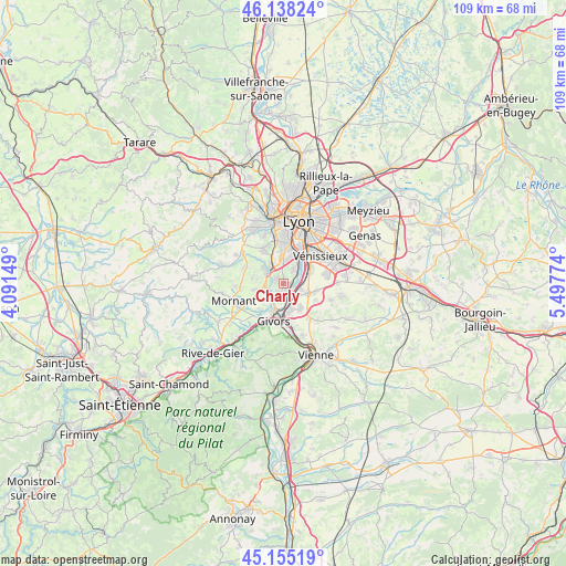
Charly GPS coordinates[2]
45° 38' 55.932" North, 4° 47' 40.596" East
| Map corner | latitude | longitude |
|---|---|---|
| Upper-left | 46.13824°, | 4.09149° |
| Center: | 45.64887°, | 4.79461° |
| Lower-right: | 45.15519°, | 5.49774° |
| Map W x H: | 109.3×109.3 km | = 67.9×67.9mi |
| max Lat: | 51.07786° ⇑71.7% North |
| Charly: | 45.64887° |
| min Lat: | ⇓28.3% South 41.3874° |
| min Long | Charly | max Long |
| -5.08615° | 4.79461° | 9.52242° |
| W 74.9%⇐ | ⇒25.1% E |
Elevation
Elevation of Charly is 233 m = 764 ft, and this is 39.3 m = 129 ft above average elevation for this country.
| Max E: |
2333 m = 7654 ft | 27.5% |
| Charly | 233 m 764 ft | |
| Avg. | 193.7 m = 635 ft | |
Min E: |
-1 m = -3 ft | 72.5% |
See also: France elevation on elevation.city.
Geographical zone
Charly is located in North temperate zone (between Tropic of Cancer and the Arctic Circle). Distance of this North polar circle is 2325.5 km =1445 mi to North.| Distance of | km | miles | from Charly |
|---|---|---|---|
| North Pole | 4931.4 | 3064.2 | to North |
| Arctic Circle | 2325.5 | 1445 | to North |
| Tropic Cancer | 2469.8 | 1534.7 | to South |
| Equator | 5075.7 | 3153.9 | to South |


Nearby cities:
15 places around Charly: (largest is in red/bold)
• Brignais
4.2 km =2.6 mi,  311°
311°
• Communay
5.9 km =3.7 mi,  147°
147°
• Feyzin
5.7 km =3.5 mi,  61°
61°
• Grigny
4.5 km =2.8 mi,  184°
184°
• Irigny
3.5 km =2.2 mi,  38°
38°
• Millery
2.1 km =1.3 mi,  207°
207°
• Montagny
4.3 km =2.7 mi,  237°
237°
• Orliénas
6 km =3.7 mi,  280°
280°
• Saint-Genis-Laval
5.2 km =3.2 mi,  358°
358°
• Solaize
3.7 km =2.3 mi,  105°
105°
• Sérézin-du-Rhône
3.2 km =2 mi,  134°
134°
• Taluyers
5.7 km =3.5 mi,  259°
259°
• Ternay
5.3 km =3.3 mi,  166°
166°
• Vernaison
1.3 km =0.8 mi,  95°
95°
• Vourles
2 km =1.2 mi,  303°
303°
Sources, notices
• [Note1] Compared only with cities in France existing in our database
• [Src1] Map data: © OpenStreetMap contributors (CC-BY-SA)
• [Src2] Other city data from geonames.org with taken over terms of usage.
• [Src3] Geographical zone / Annual Mean Temperature by Robert A. Rohde @ Wikipedia
