Sérézin-du-Rhône geodata
Sérézin-du-Rhône (Auvergne-Rhône-Alpes) is a populated place; located in France in Europe/Paris (GMT+2) time zone. With population of 2,599 people, there are 3752 cities with bigger population in this country. Compared to other cities in France, 72.1% of cities are located further ↑North; 75.4% of cities are located further ←West and 60% of cities have lower elevation than Sérézin-du-Rhône. Note1
Administrative division(s):
- Level 1: Auvergne-Rhône-Alpes
- Level 2: Département du Rhône
- Level 3: Arrondissement de Lyon
- Level 4: Sérézin-du-Rhône


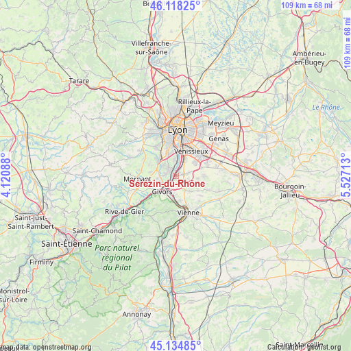
Sérézin-du-Rhône GPS coordinates[2]
45° 37' 43.356" North, 4° 49' 26.4" East
| Map corner | latitude | longitude |
|---|---|---|
| Upper-left | 46.11825°, | 4.12088° |
| Center: | 45.62871°, | 4.824° |
| Lower-right: | 45.13485°, | 5.52713° |
| Map W x H: | 109.3×109.3 km | = 67.9×67.9mi |
| max Lat: | 51.07786° ⇑72.1% North |
| Sérézin-du-Rhône: | 45.62871° |
| min Lat: | ⇓27.9% South 41.3874° |
| min Long | Sérézin-du-Rh | max Long |
| -5.08615° | 4.824° | 9.52242° |
| W 75.4%⇐ | ⇒24.6% E |
Elevation
Elevation of Sérézin-du-Rhône is 170 m = 558 ft, and this is 23.7 m = 78 ft below average elevation for this country.
| Max E: |
2333 m = 7654 ft | 40% |
| Avg. | 193.7 m = 635 ft | |
| Sérézin-du-Rhône | 170 m = 558 ft | |
Min E: |
-1 m = -3 ft | 60% |
See also: France elevation on elevation.city.
Geographical zone
Sérézin-du-Rhône is located in North temperate zone (between Tropic of Cancer and the Arctic Circle). Distance of this North polar circle is 2327.7 km =1446.4 mi to North.| Distance of | km | miles | from Sérézin-du-Rhône |
|---|---|---|---|
| North Pole | 4933.6 | 3065.6 | to North |
| Arctic Circle | 2327.7 | 1446.4 | to North |
| Tropic Cancer | 2467.5 | 1533.2 | to South |
| Equator | 5073.4 | 3152.5 | to South |


Nearby cities:
15 places around Sérézin-du-Rhône: (largest is in red/bold)
• Charly
3.2 km =2 mi,  314°
314°
• Chasse-sur-Rhône
5.7 km =3.5 mi,  191°
191°
• Chuzelles
6.4 km =4 mi,  139°
139°
• Communay
2.8 km =1.7 mi,  162°
162°
• Feyzin
5.6 km =3.5 mi,  28°
28°
• Givors
6 km =3.7 mi,  225°
225°
• Grigny
3.5 km =2.2 mi, 229°
• Irigny
4.9 km =3 mi,  358°
358°
• Millery
3.3 km =2.1 mi,  277°
277°
• Montagny
5.9 km =3.7 mi,  269°
269°
• Simandres
4 km =2.5 mi,  104°
104°
• Solaize
1.8 km =1.1 mi,  46°
46°
• Ternay
3.1 km =1.9 mi,  199°
199°
• Vernaison
2.3 km =1.4 mi,  335°
335°
• Vourles
5.2 km =3.2 mi, 310°
Sources, notices
• [Note1] Compared only with cities in France existing in our database
• [Src1] Map data: © OpenStreetMap contributors (CC-BY-SA)
• [Src2] Other city data from geonames.org with taken over terms of usage.
• [Src3] Geographical zone / Annual Mean Temperature by Robert A. Rohde @ Wikipedia
