Vernaison geodata
Vernaison (Auvergne-Rhône-Alpes) is a populated place; located in France in Europe/Paris (GMT+2) time zone. With population of 4,222 people, there are 2330 cities with bigger population in this country. Compared to other cities in France, 71.8% of cities are located further ↑North; 75.3% of cities are located further ←West and 57.6% of cities have lower elevation than Vernaison. Note1
Administrative division(s):
- Level 1: Auvergne-Rhône-Alpes
- Level 2: Département du Rhône
- Level 3: Arrondissement de Lyon
- Level 4: Vernaison


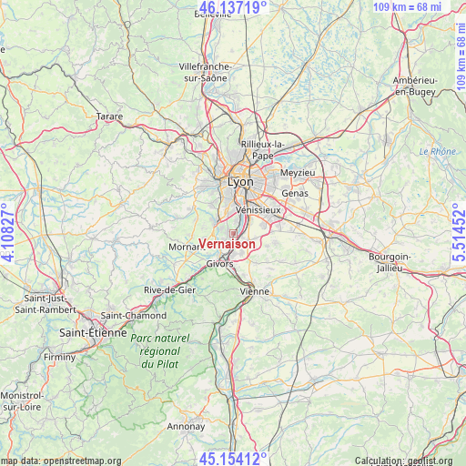
Vernaison GPS coordinates[2]
45° 38' 52.116" North, 4° 48' 41.04" East
| Map corner | latitude | longitude |
|---|---|---|
| Upper-left | 46.13719°, | 4.10827° |
| Center: | 45.64781°, | 4.8114° |
| Lower-right: | 45.15412°, | 5.51452° |
| Map W x H: | 109.3×109.3 km | = 67.9×67.9mi |
| max Lat: | 51.07786° ⇑71.8% North |
| Vernaison: | 45.64781° |
| min Lat: | ⇓28.2% South 41.3874° |
| min Long | Vernaison | max Long |
| -5.08615° | 4.8114° | 9.52242° |
| W 75.3%⇐ | ⇒24.7% E |
Elevation
Elevation of Vernaison is 160 m = 525 ft, and this is 33.7 m = 111 ft below average elevation for this country.
| Max E: |
2333 m = 7654 ft | 42.4% |
| Avg. | 193.7 m = 635 ft | |
| Vernaison | 160 m = 525 ft | |
Min E: |
-1 m = -3 ft | 57.6% |
See also: France elevation on elevation.city.
Geographical zone
Vernaison is located in North temperate zone (between Tropic of Cancer and the Arctic Circle). Distance of this North polar circle is 2325.6 km =1445.1 mi to North.| Distance of | km | miles | from Vernaison |
|---|---|---|---|
| North Pole | 4931.5 | 3064.3 | to North |
| Arctic Circle | 2325.6 | 1445.1 | to North |
| Tropic Cancer | 2469.6 | 1534.5 | to South |
| Equator | 5075.6 | 3153.8 | to South |


Nearby cities:
15 places around Vernaison: (largest is in red/bold)
• Brignais
5.3 km =3.3 mi,  303°
303°
• Charly
1.3 km =0.8 mi,  275°
275°
• Communay
5.2 km =3.2 mi,  159°
159°
• Feyzin
4.6 km =2.9 mi,  52°
52°
• Grigny
4.7 km =2.9 mi,  201°
201°
• Irigny
2.9 km =1.8 mi,  16°
16°
• Millery
2.9 km =1.8 mi,  232°
232°
• Montagny
5.4 km =3.4 mi,  246°
246°
• Pierre-Bénite
6.3 km =3.9 mi,  9°
9°
• Saint-Genis-Laval
5.5 km =3.4 mi,  345°
345°
• Simandres
5.7 km =3.5 mi,  123°
123°
• Solaize
2.4 km =1.5 mi,  111°
111°
• Sérézin-du-Rhône
2.3 km =1.4 mi, 155°
• Ternay
5.1 km =3.2 mi,  180°
180°
• Vourles
3.2 km =2 mi,  292°
292°
Sources, notices
• [Note1] Compared only with cities in France existing in our database
• [Src1] Map data: © OpenStreetMap contributors (CC-BY-SA)
• [Src2] Other city data from geonames.org with taken over terms of usage.
• [Src3] Geographical zone / Annual Mean Temperature by Robert A. Rohde @ Wikipedia
