Seyresse geodata
Seyresse (Nouvelle-Aquitaine) is a populated place; located in France in Europe/Paris (GMT+2) time zone. With population of 687 people, there are 11986 cities with bigger population in this country. Compared to other cities in France, 90.7% of cities are located further ↑North; 88.8% of cities are located further →East and 97.4% of cities have higher elevation than Seyresse. Note1
Administrative division(s):
- Level 1: Nouvelle-Aquitaine
- Level 2: Landes
- Level 3: Arrondissement de Dax
- Level 4: Seyresse


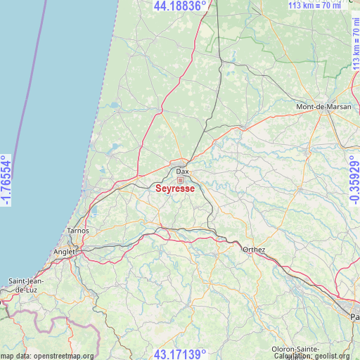
Seyresse GPS coordinates[2]
43° 40' 55.308" North, 1° 3' 44.676" West
| Map corner | latitude | longitude |
|---|---|---|
| Upper-left | 44.18836°, | -1.76554° |
| Center: | 43.68203°, | -1.06241° |
| Lower-right: | 43.17139°, | -0.35929° |
| Map W x H: | 113.1×113.1 km | = 70.3×70.3mi |
| max Lat: | 51.07786° ⇑90.7% North |
| Seyresse: | 43.68203° |
| min Lat: | ⇓9.3% South 41.3874° |
| min Long | Seyresse | max Long |
| -5.08615° | -1.06241° | 9.52242° |
| W 11.2%⇐ | ⇒88.8% E |
Elevation
Elevation of Seyresse is 10 m = 33 ft, and this is 183.7 m = 603 ft below average elevation for this country.
| Max E: |
2333 m = 7654 ft | 97.4% |
| Avg. | 193.7 m = 635 ft | |
| Seyresse | 10 m = 33 ft | |
Min E: |
-1 m = -3 ft | 2.6% |
See also: France elevation on elevation.city.
Geographical zone
Seyresse is located in North temperate zone (between Tropic of Cancer and the Arctic Circle). Distance of this Northern Tropic circle is 2251.1 km =1398.8 mi to South.| Distance of | km | miles | from Seyresse |
|---|---|---|---|
| North Pole | 5150.1 | 3200.1 | to North |
| Arctic Circle | 2544.2 | 1580.9 | to North |
| Tropic Cancer | 2251.1 | 1398.8 | to South |
| Equator | 4857 | 3018 | to South |


Nearby cities:
15 places around Seyresse: (largest is in red/bold)
• Cagnotte
9.7 km =6 mi,  182°
182°
• Candresse
7.6 km =4.7 mi,  62°
62°
• Dax
3.2 km =2 mi,  12°
12°
• Heugas
4.6 km =2.9 mi,  199°
199°
• Mimbaste
8 km =5 mi,  117°
117°
• Mées
4.5 km =2.8 mi,  303°
303°
• Narrosse
5 km =3.1 mi, 61°
• Oeyreluy
2.2 km =1.4 mi,  227°
227°
• Rivière-Saas-et-Gourby
7 km =4.3 mi,  268°
268°
• Saint-Lon-les-Mines
9.3 km =5.8 mi,  214°
214°
• Saint-Pandelon
2.3 km =1.4 mi, 124°
• Saint-Paul-lès-Dax
5.1 km =3.2 mi, 9°
• Saint-Vincent-de-Paul
8.2 km =5.1 mi,  32°
32°
• Saugnac-et-Cambran
5.6 km =3.5 mi,  102°
102°
• Tercis-les-Bains
3.8 km =2.4 mi,  250°
250°
Sources, notices
• [Note1] Compared only with cities in France existing in our database
• [Src1] Map data: © OpenStreetMap contributors (CC-BY-SA)
• [Src2] Other city data from geonames.org with taken over terms of usage.
• [Src3] Geographical zone / Annual Mean Temperature by Robert A. Rohde @ Wikipedia
