Neufchef geodata
Neufchef (Grand Est) is a populated place; located in France in Europe/Paris (GMT+2) time zone. With population of 2,557 people, there are 3812 cities with bigger population in this country. Compared to other cities in France, 86.4% of cities are located further ↓South; 87.3% of cities are located further ←West and 81.5% of cities have lower elevation than Neufchef. Note1
Administrative division(s):
- Level 1: Grand Est
- Level 2: Moselle
- Level 3: Arrondissement de Thionville
- Level 4: Neufchef


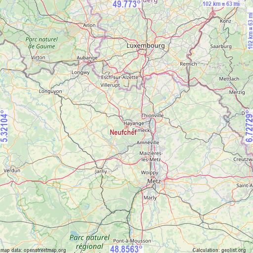
Neufchef GPS coordinates[2]
49° 19' 0.408" North, 6° 1' 26.976" East
| Map corner | latitude | longitude |
|---|---|---|
| Upper-left | 49.773°, | 5.32104° |
| Center: | 49.31678°, | 6.02416° |
| Lower-right: | 48.8563°, | 6.72729° |
| Map W x H: | 101.9×101.9 km | = 63.3×63.3mi |
| max Lat: | 51.07786° ⇑13.6% North |
| Neufchef: | 49.31678° |
| min Lat: | ⇓86.4% South 41.3874° |
| min Long | Neufchef | max Long |
| -5.08615° | 6.02416° | 9.52242° |
| W 87.3%⇐ | ⇒12.7% E |
Elevation
Elevation of Neufchef is 305 m = 1001 ft, and this is 111.3 m = 365 ft above average elevation for this country.
| Max E: |
2333 m = 7654 ft | 18.5% |
| Neufchef | 305 m 1001 ft | |
| Avg. | 193.7 m = 635 ft | |
Min E: |
-1 m = -3 ft | 81.5% |
See also: France elevation on elevation.city.
Geographical zone
Neufchef is located in North temperate zone (between Tropic of Cancer and the Arctic Circle). Distance of this North polar circle is 1917.7 km =1191.6 mi to North.| Distance of | km | miles | from Neufchef |
|---|---|---|---|
| North Pole | 4523.6 | 2810.8 | to North |
| Arctic Circle | 1917.7 | 1191.6 | to North |
| Tropic Cancer | 2877.6 | 1788.1 | to South |
| Equator | 5483.5 | 3407.3 | to South |


Nearby cities:
15 places around Neufchef: (largest is in red/bold)
• Algrange
5.5 km =3.4 mi,  20°
20°
• Avril
5.4 km =3.4 mi,  232°
232°
• Clouange
8 km =5 mi,  138°
138°
• Fameck
6.5 km =4 mi,  107°
107°
• Florange
7.1 km =4.4 mi,  83°
83°
• Fontoy
4.9 km =3 mi,  332°
332°
• Hayange
3.1 km =1.9 mi,  64°
64°
• Knutange
2.7 km =1.7 mi, 23°
• Moyeuvre-Grande
7.3 km =4.5 mi,  168°
168°
• Moyeuvre-Petite
5.2 km =3.2 mi,  178°
178°
• Nilvange
3.4 km =2.1 mi,  33°
33°
• Ranguevaux
3.1 km =1.9 mi,  133°
133°
• Rosselange
7.3 km =4.5 mi,  153°
153°
• Serémange-Erzange
4.9 km =3 mi, 84°
• Trieux
6.8 km =4.2 mi,  277°
277°
Sources, notices
• [Note1] Compared only with cities in France existing in our database
• [Src1] Map data: © OpenStreetMap contributors (CC-BY-SA)
• [Src2] Other city data from geonames.org with taken over terms of usage.
• [Src3] Geographical zone / Annual Mean Temperature by Robert A. Rohde @ Wikipedia
