Biozat geodata
Biozat (Auvergne-Rhône-Alpes) is a populated place; located in France in Europe/Paris (GMT+2) time zone. With population of 685 people, there are 12013 cities with bigger population in this country. Compared to other cities in France, 65.3% of cities are located further ↑North; 61.7% of cities are located further ←West and 85.3% of cities have lower elevation than Biozat. Note1
Administrative division(s):
- Level 1: Auvergne-Rhône-Alpes
- Level 2: Département de l'Allier
- Level 3: Arrondissement de Vichy
- Level 4: Biozat


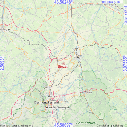
Biozat GPS coordinates[2]
46° 4' 36.768" North, 3° 16' 20.748" East
| Map corner | latitude | longitude |
|---|---|---|
| Upper-left | 46.56248°, | 2.5693° |
| Center: | 46.07688°, | 3.27243° |
| Lower-right: | 45.58697°, | 3.97555° |
| Map W x H: | 108.5×108.5 km | = 67.4×67.4mi |
| max Lat: | 51.07786° ⇑65.3% North |
| Biozat: | 46.07688° |
| min Lat: | ⇓34.7% South 41.3874° |
| min Long | Biozat | max Long |
| -5.08615° | 3.27243° | 9.52242° |
| W 61.7%⇐ | ⇒38.3% E |
Elevation
Elevation of Biozat is 350 m = 1148 ft, and this is 156.3 m = 513 ft above average elevation for this country.
| Max E: |
2333 m = 7654 ft | 14.7% |
| Biozat | 350 m 1148 ft | |
| Avg. | 193.7 m = 635 ft | |
Min E: |
-1 m = -3 ft | 85.3% |
See also: France elevation on elevation.city.
Geographical zone
Biozat is located in North temperate zone (between Tropic of Cancer and the Arctic Circle). Distance of this North polar circle is 2277.9 km =1415.4 mi to North.| Distance of | km | miles | from Biozat |
|---|---|---|---|
| North Pole | 4883.8 | 3034.7 | to North |
| Arctic Circle | 2277.9 | 1415.4 | to North |
| Tropic Cancer | 2517.3 | 1564.2 | to South |
| Equator | 5123.3 | 3183.5 | to South |


Nearby cities:
15 places around Biozat: (largest is in red/bold)
• Aigueperse
8.1 km =5 mi,  221°
221°
• Artonne
12.9 km =8 mi,  230°
230°
• Bellerive-sur-Allier
11.1 km =6.9 mi,  66°
66°
• Broût-Vernet
12.3 km =7.6 mi,  0°
0°
• Brugheas
7.4 km =4.6 mi,  90°
90°
• Cognat-Lyonne
4.5 km =2.8 mi,  39°
39°
• Effiat
4.3 km =2.7 mi,  197°
197°
• Escurolles
7.4 km =4.6 mi,  355°
355°
• Espinasse-Vozelle
6.8 km =4.2 mi, 35°
• Gannat
6.3 km =3.9 mi,  294°
294°
• Pragoulin
9.7 km =6 mi,  105°
105°
• Randan
9.2 km =5.7 mi,  136°
136°
• Serbannes
7.1 km =4.4 mi, 70°
• Thuret
12 km =7.5 mi,  185°
185°
• Vendat
11.5 km =7.1 mi,  32°
32°
Sources, notices
• [Note1] Compared only with cities in France existing in our database
• [Src1] Map data: © OpenStreetMap contributors (CC-BY-SA)
• [Src2] Other city data from geonames.org with taken over terms of usage.
• [Src3] Geographical zone / Annual Mean Temperature by Robert A. Rohde @ Wikipedia
