Sénergues geodata
Sénergues (Occitanie) is a populated place; located in France in Europe/Paris (GMT+2) time zone. With population of 565 people, there are 13917 cities with bigger population in this country. Compared to other cities in France, 82.7% of cities are located further ↑North; 50.3% of cities are located further ←West and 92.9% of cities have lower elevation than Sénergues. Note1
Administrative division(s):
- Level 1: Occitanie
- Level 2: Département de l'Aveyron
- Level 3: Arrondissement de Rodez
- Level 4: Sénergues


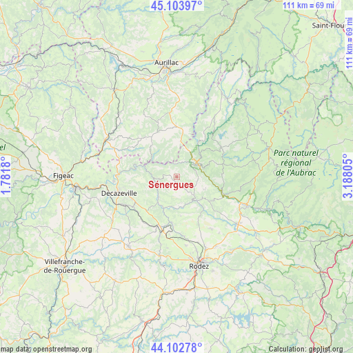
Sénergues GPS coordinates[2]
44° 36' 19.908" North, 2° 29' 5.748" East
| Map corner | latitude | longitude |
|---|---|---|
| Upper-left | 45.10397°, | 1.7818° |
| Center: | 44.60553°, | 2.48493° |
| Lower-right: | 44.10278°, | 3.18805° |
| Map W x H: | 111.3×111.3 km | = 69.2×69.2mi |
| max Lat: | 51.07786° ⇑82.7% North |
| Sénergues: | 44.60553° |
| min Lat: | ⇓17.3% South 41.3874° |
| min Long | Sénergues | max Long |
| -5.08615° | 2.48493° | 9.52242° |
| W 50.3%⇐ | ⇒49.7% E |
Elevation
Elevation of Sénergues is 501 m = 1644 ft, and this is 307.3 m = 1008 ft above average elevation for this country.
| Max E: |
2333 m = 7654 ft | 7.1% |
| Sénergues | 501 m 1644 ft | |
| Avg. | 193.7 m = 635 ft | |
Min E: |
-1 m = -3 ft | 92.9% |
See also: France elevation on elevation.city.
Geographical zone
Sénergues is located in North temperate zone (between Tropic of Cancer and the Arctic Circle). Distance of this Northern Tropic circle is 2353.8 km =1462.6 mi to South.| Distance of | km | miles | from Sénergues |
|---|---|---|---|
| North Pole | 5047.4 | 3136.3 | to North |
| Arctic Circle | 2441.5 | 1517.1 | to North |
| Tropic Cancer | 2353.8 | 1462.6 | to South |
| Equator | 4959.7 | 3081.8 | to South |


Nearby cities:
15 places around Sénergues: (largest is in red/bold)
• Auzits
16.6 km =10.3 mi,  228°
228°
• Cassaniouze
12.5 km =7.8 mi,  319°
319°
• Cransac
18.3 km =11.4 mi,  240°
240°
• Entraygues-sur-Truyère
7.9 km =4.9 mi,  55°
55°
• Estaing
15.8 km =9.8 mi,  110°
110°
• Firmi
15.8 km =9.8 mi, 242°
• Flagnac
18.7 km =11.6 mi,  269°
269°
• Le Nayrac
14.3 km =8.9 mi,  86°
86°
• Marcillac-Vallon
14.6 km =9.1 mi,  186°
186°
• Montsalvy
11.4 km =7.1 mi,  6°
6°
• Rodelle
16.8 km =10.4 mi,  139°
139°
• Saint-Amans-des-Cots
16.7 km =10.4 mi, 57°
• Saint-Christophe-Vallon
16.1 km =10 mi,  201°
201°
• Saint-Cyprien-sur-Dourdou
8.6 km =5.3 mi,  221°
221°
• Valady
17.2 km =10.7 mi, 195°
Sources, notices
• [Note1] Compared only with cities in France existing in our database
• [Src1] Map data: © OpenStreetMap contributors (CC-BY-SA)
• [Src2] Other city data from geonames.org with taken over terms of usage.
• [Src3] Geographical zone / Annual Mean Temperature by Robert A. Rohde @ Wikipedia
