Montsalvy geodata
Montsalvy (Auvergne-Rhône-Alpes) is a populated place; located in France in Europe/Paris (GMT+2) time zone. With population of 903 people, there are 9626 cities with bigger population in this country. Compared to other cities in France, 82.1% of cities are located further ↑North; 50.6% of cities are located further ←West and 97.6% of cities have lower elevation than Montsalvy. Note1
Administrative division(s):
- Level 1: Auvergne-Rhône-Alpes
- Level 2: Cantal
- Level 3: Aurillac
- Level 4: Montsalvy


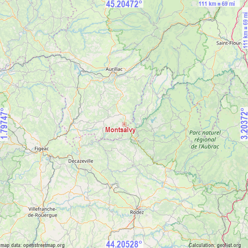
Montsalvy GPS coordinates[2]
44° 42' 25.776" North, 2° 30' 2.124" East
| Map corner | latitude | longitude |
|---|---|---|
| Upper-left | 45.20472°, | 1.79747° |
| Center: | 44.70716°, | 2.50059° |
| Lower-right: | 44.20528°, | 3.20372° |
| Map W x H: | 111.1×111.1 km | = 69×69mi |
| max Lat: | 51.07786° ⇑82.1% North |
| Montsalvy: | 44.70716° |
| min Lat: | ⇓17.9% South 41.3874° |
| min Long | Montsalvy | max Long |
| -5.08615° | 2.50059° | 9.52242° |
| W 50.6%⇐ | ⇒49.4% E |
Elevation
Elevation of Montsalvy is 785 m = 2575 ft, and this is 591.3 m = 1940 ft above average elevation for this country.
| Max E: |
2333 m = 7654 ft | 2.4% |
| Montsalvy | 785 m 2575 ft | |
| Avg. | 193.7 m = 635 ft | |
Min E: |
-1 m = -3 ft | 97.6% |
See also: France elevation on elevation.city.
Geographical zone
Montsalvy is located in North temperate zone (between Tropic of Cancer and the Arctic Circle). Distance of this Northern Tropic circle is 2365.1 km =1469.6 mi to South.| Distance of | km | miles | from Montsalvy |
|---|---|---|---|
| North Pole | 5036.1 | 3129.3 | to North |
| Arctic Circle | 2430.2 | 1510.1 | to North |
| Tropic Cancer | 2365.1 | 1469.6 | to South |
| Equator | 4971 | 3088.8 | to South |


Nearby cities:
15 places around Montsalvy: (largest is in red/bold)
• Boisset
21.2 km =13.2 mi,  293°
293°
• Brommat
19.9 km =12.4 mi,  46°
46°
• Cassaniouze
9.5 km =5.9 mi,  259°
259°
• Entraygues-sur-Truyère
8.6 km =5.3 mi,  142°
142°
• Lacroix-Barrez
13.5 km =8.4 mi, 53°
• Lafeuillade-en-Vézie
9.7 km =6 mi,  340°
340°
• Le Nayrac
16.7 km =10.4 mi,  128°
128°
• Marcolès
14.3 km =8.9 mi,  305°
305°
• Mur-de-Barrez
19.8 km =12.3 mi,  39°
39°
• Prunet
12.9 km =8 mi,  346°
346°
• Roannes-Saint-Mary
18.8 km =11.7 mi,  332°
332°
• Saint-Amans-des-Cots
13 km =8.1 mi,  100°
100°
• Saint-Cyprien-sur-Dourdou
19.1 km =11.9 mi,  201°
201°
• Sénergues
11.4 km =7.1 mi,  186°
186°
• Taussac
17.6 km =10.9 mi, 39°
Sources, notices
• [Note1] Compared only with cities in France existing in our database
• [Src1] Map data: © OpenStreetMap contributors (CC-BY-SA)
• [Src2] Other city data from geonames.org with taken over terms of usage.
• [Src3] Geographical zone / Annual Mean Temperature by Robert A. Rohde @ Wikipedia
