Entraygues-sur-Truyère geodata
Entraygues-sur-Truyère (Occitanie) is a populated place; located in France in Europe/Paris (GMT+2) time zone. With population of 1,417 people, there are 6530 cities with bigger population in this country. Compared to other cities in France, 82.5% of cities are located further ↑North; 51.7% of cities are located further ←West and 76.2% of cities have lower elevation than Entraygues-sur-Truyère. Note1
Administrative division(s):
- Level 1: Occitanie
- Level 2: Département de l'Aveyron
- Level 3: Arrondissement de Rodez
- Level 4: Entraygues-sur-Truyère
Current local time in Entraygues-sur-Truyère:
10:02 AM, SaturdayDifference from your time zone: hours


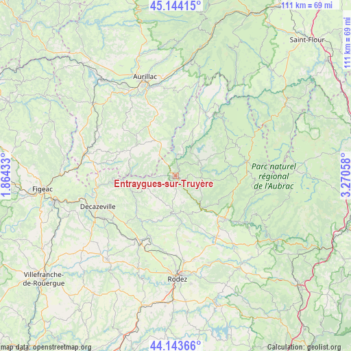
Entraygues-sur-Truyère GPS coordinates[2]
44° 38' 45.816" North, 2° 34' 2.82" East
| Map corner | latitude | longitude |
|---|---|---|
| Upper-left | 45.14415°, | 1.86433° |
| Center: | 44.64606°, | 2.56745° |
| Lower-right: | 44.14366°, | 3.27058° |
| Map W x H: | 111.2×111.2 km | = 69.1×69.1mi |
| max Lat: | 51.07786° ⇑82.5% North |
| Entraygues-sur-Truyère: | 44.64606° |
| min Lat: | ⇓17.5% South 41.3874° |
| min Long | Entraygues-sur- | max Long |
| -5.08615° | 2.56745° | 9.52242° |
| W 51.7%⇐ | ⇒48.3% E |
Elevation
Elevation of Entraygues-sur-Truyère is 258 m = 846 ft, and this is 64.3 m = 211 ft above average elevation for this country.
| Max E: |
2333 m = 7654 ft | 23.8% |
| Entraygues-sur-Truyère | 258 m 846 ft | |
| Avg. | 193.7 m = 635 ft | |
Min E: |
-1 m = -3 ft | 76.2% |
See also: France elevation on elevation.city.
Geographical zone
Entraygues-sur-Truyère is located in North temperate zone (between Tropic of Cancer and the Arctic Circle). Distance of this Northern Tropic circle is 2358.3 km =1465.4 mi to South.| Distance of | km | miles | from Entraygues-sur-Truyère |
|---|---|---|---|
| North Pole | 5042.9 | 3133.5 | to North |
| Arctic Circle | 2437 | 1514.3 | to North |
| Tropic Cancer | 2358.3 | 1465.4 | to South |
| Equator | 4964.2 | 3084.6 | to South |


Nearby cities:
15 places around Entraygues-sur-Truyère: (largest is in red/bold)
• Cassaniouze
15.4 km =9.6 mi,  288°
288°
• Coubisou
16.5 km =10.3 mi,  129°
129°
• Espalion
20.7 km =12.9 mi, 131°
• Estaing
13 km =8.1 mi,  140°
140°
• Lacroix-Barrez
15.9 km =9.9 mi,  20°
20°
• Lafeuillade-en-Vézie
18 km =11.2 mi,  331°
331°
• Le Nayrac
8.5 km =5.3 mi,  115°
115°
• Marcillac-Vallon
20.7 km =12.9 mi,  203°
203°
• Montpeyroux
20.3 km =12.6 mi,  91°
91°
• Montsalvy
8.6 km =5.3 mi,  322°
322°
• Prunet
21.1 km =13.1 mi,  337°
337°
• Rodelle
17.8 km =11.1 mi,  165°
165°
• Saint-Amans-des-Cots
8.7 km =5.4 mi,  58°
58°
• Saint-Cyprien-sur-Dourdou
16.4 km =10.2 mi,  228°
228°
• Sénergues
7.9 km =4.9 mi,  235°
235°
Sources, notices
• [Note1] Compared only with cities in France existing in our database
• [Src1] Map data: © OpenStreetMap contributors (CC-BY-SA)
• [Src2] Other city data from geonames.org with taken over terms of usage.
• [Src3] Geographical zone / Annual Mean Temperature by Robert A. Rohde @ Wikipedia
