Gièvres geodata
Gièvres (Centre) is a populated place; located in France in Europe/Paris (GMT+2) time zone. With population of 2,214 people, there are 4340 cities with bigger population in this country. Compared to other cities in France, 51.9% of cities are located further ↑North; 60.8% of cities are located further →East and 63.6% of cities have higher elevation than Gièvres. Note1
Administrative division(s):
- Level 1: Centre
- Level 2: Département du Loir-et-Cher
- Level 3: Arrondissement de Romorantin-Lanthenay
- Level 4: Gièvres


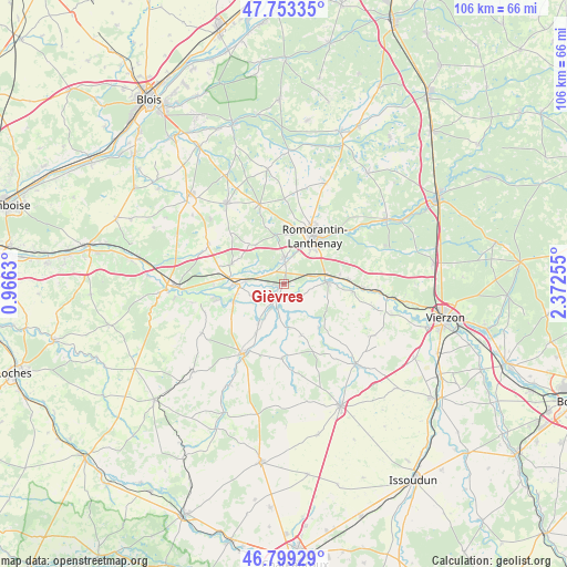
Gièvres GPS coordinates[2]
47° 16' 42.492" North, 1° 40' 9.948" East
| Map corner | latitude | longitude |
|---|---|---|
| Upper-left | 47.75335°, | 0.9663° |
| Center: | 47.27847°, | 1.66943° |
| Lower-right: | 46.79929°, | 2.37255° |
| Map W x H: | 106.1×106.1 km | = 65.9×65.9mi |
| max Lat: | 51.07786° ⇑51.9% North |
| Gièvres: | 47.27847° |
| min Lat: | ⇓48.1% South 41.3874° |
| min Long | Gièvres | max Long |
| -5.08615° | 1.66943° | 9.52242° |
| W 39.2%⇐ | ⇒60.8% E |
Elevation
Elevation of Gièvres is 93 m = 305 ft, and this is 100.7 m = 330 ft below average elevation for this country.
| Max E: |
2333 m = 7654 ft | 63.6% |
| Avg. | 193.7 m = 635 ft | |
| Gièvres | 93 m = 305 ft | |
Min E: |
-1 m = -3 ft | 36.4% |
See also: France elevation on elevation.city.
Geographical zone
Gièvres is located in North temperate zone (between Tropic of Cancer and the Arctic Circle). Distance of this North polar circle is 2144.3 km =1332.4 mi to North.| Distance of | km | miles | from Gièvres |
|---|---|---|---|
| North Pole | 4750.2 | 2951.6 | to North |
| Arctic Circle | 2144.3 | 1332.4 | to North |
| Tropic Cancer | 2651 | 1647.3 | to South |
| Equator | 5256.9 | 3266.5 | to South |


Nearby cities:
15 places around Gièvres: (largest is in red/bold)
• Billy
10.5 km =6.5 mi,  291°
291°
• Chabris
3.1 km =1.9 mi,  205°
205°
• Châtillon-sur-Cher
13.2 km =8.2 mi,  268°
268°
• Gy-en-Sologne
9.8 km =6.1 mi,  318°
318°
• La Vernelle
10.1 km =6.3 mi,  250°
250°
• Langon
11.8 km =7.3 mi,  86°
86°
• Meusnes
13.4 km =8.3 mi,  255°
255°
• Poulaines
14.1 km =8.8 mi,  181°
181°
• Pruniers-en-Sologne
4.3 km =2.7 mi,  357°
357°
• Romorantin-Lanthenay
11.5 km =7.1 mi,  31°
31°
• Saint-Julien-sur-Cher
7.9 km =4.9 mi, 87°
• Selles-sur-Cher
8.7 km =5.4 mi, 270°
• Varennes-sur-Fouzon
8.7 km =5.4 mi, 213°
• Villefranche-sur-Cher
7.7 km =4.8 mi,  71°
71°
• Villeherviers
13.9 km =8.6 mi,  45°
45°
Sources, notices
• [Note1] Compared only with cities in France existing in our database
• [Src1] Map data: © OpenStreetMap contributors (CC-BY-SA)
• [Src2] Other city data from geonames.org with taken over terms of usage.
• [Src3] Geographical zone / Annual Mean Temperature by Robert A. Rohde @ Wikipedia
