Varennes-sur-Fouzon geodata
Varennes-sur-Fouzon (Centre) is a populated place; located in France in Europe/Paris (GMT+2) time zone. With population of 697 people, there are 11838 cities with bigger population in this country. Compared to other cities in France, 52.9% of cities are located further ↑North; 61.7% of cities are located further →East and 65.3% of cities have higher elevation than Varennes-sur-Fouzon. Note1
Administrative division(s):
- Level 1: Centre
- Level 2: Département de l'Indre
- Level 3: Arrondissement d'Issoudun
- Level 4: Val-Fouzon


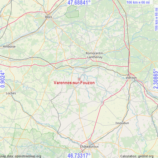
Varennes-sur-Fouzon GPS coordinates[2]
47° 12' 46.584" North, 1° 36' 19.872" East
| Map corner | latitude | longitude |
|---|---|---|
| Upper-left | 47.68841°, | 0.9024° |
| Center: | 47.21294°, | 1.60552° |
| Lower-right: | 46.73317°, | 2.30865° |
| Map W x H: | 106.2×106.2 km | = 66×66mi |
| max Lat: | 51.07786° ⇑52.9% North |
| Varennes-sur-Fouzon: | 47.21294° |
| min Lat: | ⇓47.1% South 41.3874° |
| min Long | Varennes-sur-Fo | max Long |
| -5.08615° | 1.60552° | 9.52242° |
| W 38.3%⇐ | ⇒61.7% E |
Elevation
Elevation of Varennes-sur-Fouzon is 89 m = 292 ft, and this is 104.7 m = 344 ft below average elevation for this country.
| Max E: |
2333 m = 7654 ft | 65.3% |
| Avg. | 193.7 m = 635 ft | |
| Varennes-sur-Fouzon | 89 m = 292 ft | |
Min E: |
-1 m = -3 ft | 34.7% |
See also: France elevation on elevation.city.
Geographical zone
Varennes-sur-Fouzon is located in North temperate zone (between Tropic of Cancer and the Arctic Circle). Distance of this North polar circle is 2151.6 km =1336.9 mi to North.| Distance of | km | miles | from Varennes-sur-Fouzon |
|---|---|---|---|
| North Pole | 4757.5 | 2956.2 | to North |
| Arctic Circle | 2151.6 | 1336.9 | to North |
| Tropic Cancer | 2643.7 | 1642.7 | to South |
| Equator | 5249.6 | 3261.9 | to South |


Nearby cities:
15 places around Varennes-sur-Fouzon: (largest is in red/bold)
• Billy
12.1 km =7.5 mi,  335°
335°
• Chabris
5.7 km =3.5 mi,  37°
37°
• Châtillon-sur-Cher
10.9 km =6.8 mi,  309°
309°
• Couffy
13.1 km =8.1 mi,  287°
287°
• Gièvres
8.7 km =5.4 mi,  33°
33°
• Gy-en-Sologne
14.7 km =9.1 mi,  353°
353°
• La Vernelle
6.2 km =3.9 mi, 309°
• Lye
10.1 km =6.3 mi,  279°
279°
• Meusnes
9.1 km =5.7 mi,  296°
296°
• Poulaines
8 km =5 mi,  147°
147°
• Pruniers-en-Sologne
12.4 km =7.7 mi,  21°
21°
• Selles-sur-Cher
8.3 km =5.2 mi,  332°
332°
• Valençay
6.3 km =3.9 mi,  206°
206°
• Vicq-sur-Nahon
12.9 km =8 mi,  203°
203°
• Villentrois
11 km =6.8 mi,  259°
259°
Sources, notices
• [Note1] Compared only with cities in France existing in our database
• [Src1] Map data: © OpenStreetMap contributors (CC-BY-SA)
• [Src2] Other city data from geonames.org with taken over terms of usage.
• [Src3] Geographical zone / Annual Mean Temperature by Robert A. Rohde @ Wikipedia
