Pruniers-en-Sologne geodata
Pruniers-en-Sologne (Centre) is a populated place; located in France in Europe/Paris (GMT+2) time zone. With population of 2,277 people, there are 4230 cities with bigger population in this country. Compared to other cities in France, 51.3% of cities are located further ↑North; 60.8% of cities are located further →East and 69.2% of cities have higher elevation than Pruniers-en-Sologne. Note1
Administrative division(s):
- Level 1: Centre
- Level 2: Département du Loir-et-Cher
- Level 3: Arrondissement de Romorantin-Lanthenay
- Level 4: Pruniers-en-Sologne


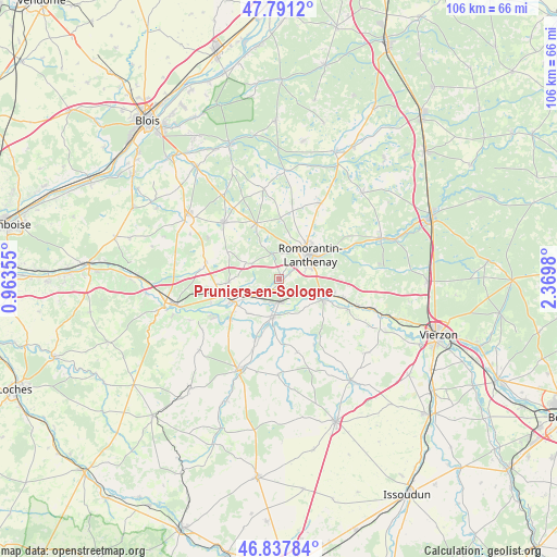
Pruniers-en-Sologne GPS coordinates[2]
47° 19' 0.012" North, 1° 40' 0.012" East
| Map corner | latitude | longitude |
|---|---|---|
| Upper-left | 47.7912°, | 0.96355° |
| Center: | 47.31667°, | 1.66667° |
| Lower-right: | 46.83784°, | 2.3698° |
| Map W x H: | 106×106 km | = 65.9×65.9mi |
| max Lat: | 51.07786° ⇑51.3% North |
| Pruniers-en-Sologne: | 47.31667° |
| min Lat: | ⇓48.7% South 41.3874° |
| min Long | Pruniers-en-Sol | max Long |
| -5.08615° | 1.66667° | 9.52242° |
| W 39.2%⇐ | ⇒60.8% E |
Elevation
Elevation of Pruniers-en-Sologne is 80 m = 262 ft, and this is 113.7 m = 373 ft below average elevation for this country.
| Max E: |
2333 m = 7654 ft | 69.2% |
| Avg. | 193.7 m = 635 ft | |
| Pruniers-en-Sologne | 80 m = 262 ft | |
Min E: |
-1 m = -3 ft | 30.8% |
See also: France elevation on elevation.city.
Geographical zone
Pruniers-en-Sologne is located in North temperate zone (between Tropic of Cancer and the Arctic Circle). Distance of this North polar circle is 2140.1 km =1329.8 mi to North.| Distance of | km | miles | from Pruniers-en-Sologne |
|---|---|---|---|
| North Pole | 4745.9 | 2949 | to North |
| Arctic Circle | 2140.1 | 1329.8 | to North |
| Tropic Cancer | 2655.2 | 1649.9 | to South |
| Equator | 5261.1 | 3269.1 | to South |


Nearby cities:
15 places around Pruniers-en-Sologne: (largest is in red/bold)
• Billy
9.6 km =6 mi,  267°
267°
• Chabris
7.1 km =4.4 mi,  189°
189°
• Châtillon-sur-Cher
13.8 km =8.6 mi,  250°
250°
• Chémery
14.5 km =9 mi,  283°
283°
• Gièvres
4.3 km =2.7 mi,  177°
177°
• Gy-en-Sologne
7.1 km =4.4 mi,  295°
295°
• La Vernelle
12 km =7.5 mi,  230°
230°
• Langon
12.5 km =7.8 mi,  106°
106°
• Mur-de-Sologne
11.5 km =7.1 mi,  337°
337°
• Romorantin-Lanthenay
8.4 km =5.2 mi,  48°
48°
• Saint-Julien-sur-Cher
9 km =5.6 mi,  115°
115°
• Selles-sur-Cher
9.5 km =5.9 mi,  243°
243°
• Varennes-sur-Fouzon
12.4 km =7.7 mi,  201°
201°
• Villefranche-sur-Cher
7.8 km =4.8 mi,  103°
103°
• Villeherviers
11.5 km =7.1 mi,  61°
61°
Sources, notices
• [Note1] Compared only with cities in France existing in our database
• [Src1] Map data: © OpenStreetMap contributors (CC-BY-SA)
• [Src2] Other city data from geonames.org with taken over terms of usage.
• [Src3] Geographical zone / Annual Mean Temperature by Robert A. Rohde @ Wikipedia
