Royat geodata
Royat (Auvergne-Rhône-Alpes) is a populated place; located in France in Europe/Paris (GMT+2) time zone. With population of 4,831 people, there are 2051 cities with bigger population in this country. Compared to other cities in France, 69.8% of cities are located further ↑North; 58.5% of cities are located further ←West and 93.5% of cities have lower elevation than Royat. Note1
Administrative division(s):
- Level 1: Auvergne-Rhône-Alpes
- Level 2: Département du Puy-de-Dôme
- Level 3: Arrondissement de Clermont-Ferrand
- Level 4: Royat


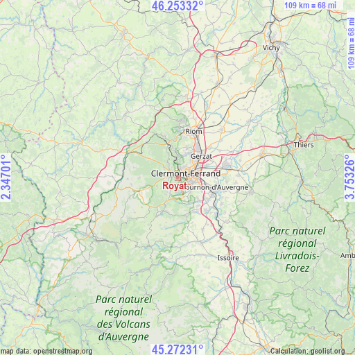
Royat GPS coordinates[2]
45° 45' 53.892" North, 3° 3' 0.468" East
| Map corner | latitude | longitude |
|---|---|---|
| Upper-left | 46.25332°, | 2.34701° |
| Center: | 45.76497°, | 3.05013° |
| Lower-right: | 45.27231°, | 3.75326° |
| Map W x H: | 109.1×109.1 km | = 67.8×67.8mi |
| max Lat: | 51.07786° ⇑69.8% North |
| Royat: | 45.76497° |
| min Lat: | ⇓30.2% South 41.3874° |
| min Long | Royat | max Long |
| -5.08615° | 3.05013° | 9.52242° |
| W 58.5%⇐ | ⇒41.5% E |
Elevation
Elevation of Royat is 521 m = 1709 ft, and this is 327.3 m = 1074 ft above average elevation for this country.
| Max E: |
2333 m = 7654 ft | 6.5% |
| Royat | 521 m 1709 ft | |
| Avg. | 193.7 m = 635 ft | |
Min E: |
-1 m = -3 ft | 93.5% |
See also: France elevation on elevation.city.
Geographical zone
Royat is located in North temperate zone (between Tropic of Cancer and the Arctic Circle). Distance of this North polar circle is 2312.6 km =1437 mi to North.| Distance of | km | miles | from Royat |
|---|---|---|---|
| North Pole | 4918.5 | 3056.2 | to North |
| Arctic Circle | 2312.6 | 1437 | to North |
| Tropic Cancer | 2482.7 | 1542.7 | to South |
| Equator | 5088.6 | 3161.9 | to South |


Nearby cities:
15 places around Royat: (largest is in red/bold)
• Aubière
5 km =3.1 mi,  108°
108°
• Beaumont
2.9 km =1.8 mi,  120°
120°
• Blanzat
7.5 km =4.7 mi,  16°
16°
• Ceyrat
3.7 km =2.3 mi,  164°
164°
• Chamalières
1.6 km =1 mi,  53°
53°
• Chanat-la-Mouteyre
7.8 km =4.8 mi,  339°
339°
• Clermont-Ferrand
3.3 km =2.1 mi,  60°
60°
• Cébazat
8.3 km =5.2 mi,  27°
27°
• Durtol
3.5 km =2.2 mi,  1°
1°
• Nohanent
4.8 km =3 mi, 4°
• Orcines
3.5 km =2.2 mi,  303°
303°
• Pérignat-lès-Sarliève
7.6 km =4.7 mi, 114°
• Romagnat
5.6 km =3.5 mi,  135°
135°
• Saint-Genès-Champanelle
5.5 km =3.4 mi,  206°
206°
• Sayat
6.8 km =4.2 mi, 1°
Sources, notices
• [Note1] Compared only with cities in France existing in our database
• [Src1] Map data: © OpenStreetMap contributors (CC-BY-SA)
• [Src2] Other city data from geonames.org with taken over terms of usage.
• [Src3] Geographical zone / Annual Mean Temperature by Robert A. Rohde @ Wikipedia
