Nohanent geodata
Nohanent (Auvergne-Rhône-Alpes) is a populated place; located in France in Europe/Paris (GMT+2) time zone. With population of 1,868 people, there are 5089 cities with bigger population in this country. Compared to other cities in France, 69.1% of cities are located further ↑North; 58.6% of cities are located further ←West and 94% of cities have lower elevation than Nohanent. Note1
Administrative division(s):
- Level 1: Auvergne-Rhône-Alpes
- Level 2: Département du Puy-de-Dôme
- Level 3: Arrondissement de Clermont-Ferrand
- Level 4: Nohanent


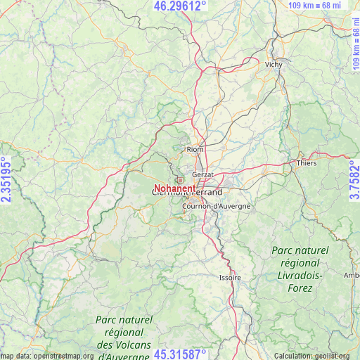
Nohanent GPS coordinates[2]
45° 48' 29.34" North, 3° 3' 18.252" East
| Map corner | latitude | longitude |
|---|---|---|
| Upper-left | 46.29612°, | 2.35195° |
| Center: | 45.80815°, | 3.05507° |
| Lower-right: | 45.31587°, | 3.7582° |
| Map W x H: | 109×109 km | = 67.7×67.7mi |
| max Lat: | 51.07786° ⇑69.1% North |
| Nohanent: | 45.80815° |
| min Lat: | ⇓30.9% South 41.3874° |
| min Long | Nohanent | max Long |
| -5.08615° | 3.05507° | 9.52242° |
| W 58.6%⇐ | ⇒41.4% E |
Elevation
Elevation of Nohanent is 542 m = 1778 ft, and this is 348.3 m = 1143 ft above average elevation for this country.
| Max E: |
2333 m = 7654 ft | 6% |
| Nohanent | 542 m 1778 ft | |
| Avg. | 193.7 m = 635 ft | |
Min E: |
-1 m = -3 ft | 94% |
See also: France elevation on elevation.city.
Geographical zone
Nohanent is located in North temperate zone (between Tropic of Cancer and the Arctic Circle). Distance of this North polar circle is 2307.8 km =1434 mi to North.| Distance of | km | miles | from Nohanent |
|---|---|---|---|
| North Pole | 4913.7 | 3053.2 | to North |
| Arctic Circle | 2307.8 | 1434 | to North |
| Tropic Cancer | 2487.5 | 1545.7 | to South |
| Equator | 5093.4 | 3164.9 | to South |


Nearby cities:
15 places around Nohanent: (largest is in red/bold)
• Aubière
7.7 km =4.8 mi,  145°
145°
• Beaumont
6.6 km =4.1 mi,  161°
161°
• Blanzat
3 km =1.9 mi,  36°
36°
• Chamalières
3.9 km =2.4 mi,  166°
166°
• Chanat-la-Mouteyre
4 km =2.5 mi,  309°
309°
• Châteaugay
5.3 km =3.3 mi,  25°
25°
• Clermont-Ferrand
4 km =2.5 mi,  142°
142°
• Cébazat
4.3 km =2.7 mi,  53°
53°
• Durtol
1.4 km =0.9 mi,  191°
191°
• Gerzat
7.2 km =4.5 mi,  74°
74°
• Malauzat
4.4 km =2.7 mi,  357°
357°
• Orcines
4.4 km =2.7 mi,  229°
229°
• Royat
4.8 km =3 mi,  184°
184°
• Sayat
2 km =1.2 mi,  354°
354°
• Volvic
7.2 km =4.5 mi, 349°
Sources, notices
• [Note1] Compared only with cities in France existing in our database
• [Src1] Map data: © OpenStreetMap contributors (CC-BY-SA)
• [Src2] Other city data from geonames.org with taken over terms of usage.
• [Src3] Geographical zone / Annual Mean Temperature by Robert A. Rohde @ Wikipedia
