Clastres geodata
Clastres (Hauts-de-France) is a populated place; located in France in Europe/Paris (GMT+2) time zone. With population of 507 people, there are 15105 cities with bigger population in this country. Compared to other cities in France, 91.9% of cities are located further ↓South; 61% of cities are located further ←West and 69.7% of cities have higher elevation than Clastres. Note1
Administrative division(s):
- Level 1: Hauts-de-France
- Level 2: Département de l'Aisne
- Level 3: Arrondissement de Saint-Quentin
- Level 4: Clastres


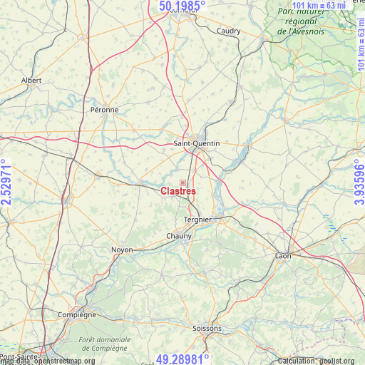
Clastres GPS coordinates[2]
49° 44' 46.608" North, 3° 13' 58.188" East
| Map corner | latitude | longitude |
|---|---|---|
| Upper-left | 50.1985°, | 2.52971° |
| Center: | 49.74628°, | 3.23283° |
| Lower-right: | 49.28981°, | 3.93596° |
| Map W x H: | 101×101 km | = 62.8×62.8mi |
| max Lat: | 51.07786° ⇑8.1% North |
| Clastres: | 49.74628° |
| min Lat: | ⇓91.9% South 41.3874° |
| min Long | Clastres | max Long |
| -5.08615° | 3.23283° | 9.52242° |
| W 61%⇐ | ⇒39% E |
Elevation
Elevation of Clastres is 79 m = 259 ft, and this is 114.7 m = 376 ft below average elevation for this country.
| Max E: |
2333 m = 7654 ft | 69.7% |
| Avg. | 193.7 m = 635 ft | |
| Clastres | 79 m = 259 ft | |
Min E: |
-1 m = -3 ft | 30.3% |
See also: France elevation on elevation.city.
Geographical zone
Clastres is located in North temperate zone (between Tropic of Cancer and the Arctic Circle). Distance of this North polar circle is 1869.9 km =1161.9 mi to North.| Distance of | km | miles | from Clastres |
|---|---|---|---|
| North Pole | 4475.8 | 2781.1 | to North |
| Arctic Circle | 1869.9 | 1161.9 | to North |
| Tropic Cancer | 2925.3 | 1817.7 | to South |
| Equator | 5531.3 | 3437 | to South |


Nearby cities:
15 places around Clastres: (largest is in red/bold)
• Brouchy
10.1 km =6.3 mi,  250°
250°
• Cugny
7.2 km =4.5 mi,  233°
233°
• Essigny-le-Grand
4.8 km =3 mi,  41°
41°
• Flavy-le-Martel
4.7 km =2.9 mi,  218°
218°
• Frières-Faillouël
6.5 km =4 mi,  173°
173°
• Gauchy
9.5 km =5.9 mi,  17°
17°
• Grugies
7.8 km =4.8 mi, 19°
• Jussy
2.9 km =1.8 mi,  180°
180°
• Montescourt-Lizerolles
2 km =1.2 mi,  116°
116°
• Saint-Simon
4 km =2.5 mi,  269°
269°
• Savy
9.8 km =6.1 mi,  343°
343°
• Seraucourt-le-Grand
4.3 km =2.7 mi, 344°
• Urvillers
7.4 km =4.6 mi,  48°
48°
• Vendeuil
9.2 km =5.7 mi,  111°
111°
• Villequier-Aumont
10 km =6.2 mi,  190°
190°
Sources, notices
• [Note1] Compared only with cities in France existing in our database
• [Src1] Map data: © OpenStreetMap contributors (CC-BY-SA)
• [Src2] Other city data from geonames.org with taken over terms of usage.
• [Src3] Geographical zone / Annual Mean Temperature by Robert A. Rohde @ Wikipedia
